 |
| What's New | Links | FAQ | Contact |

GPS Track Suggested Parking Park Map: Highlighted Original (PDF) Topographic Map Park Website Photos |
Black Diamond Mines 95% FIRE ROAD5% PAVED 
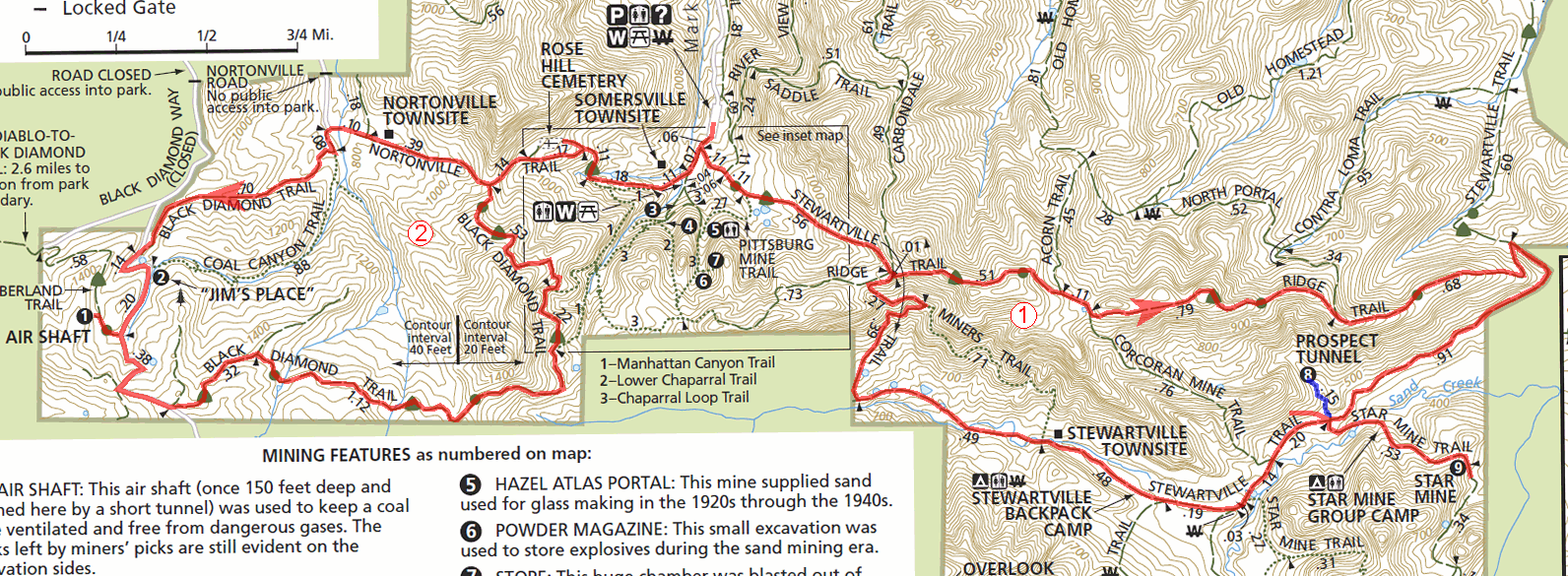
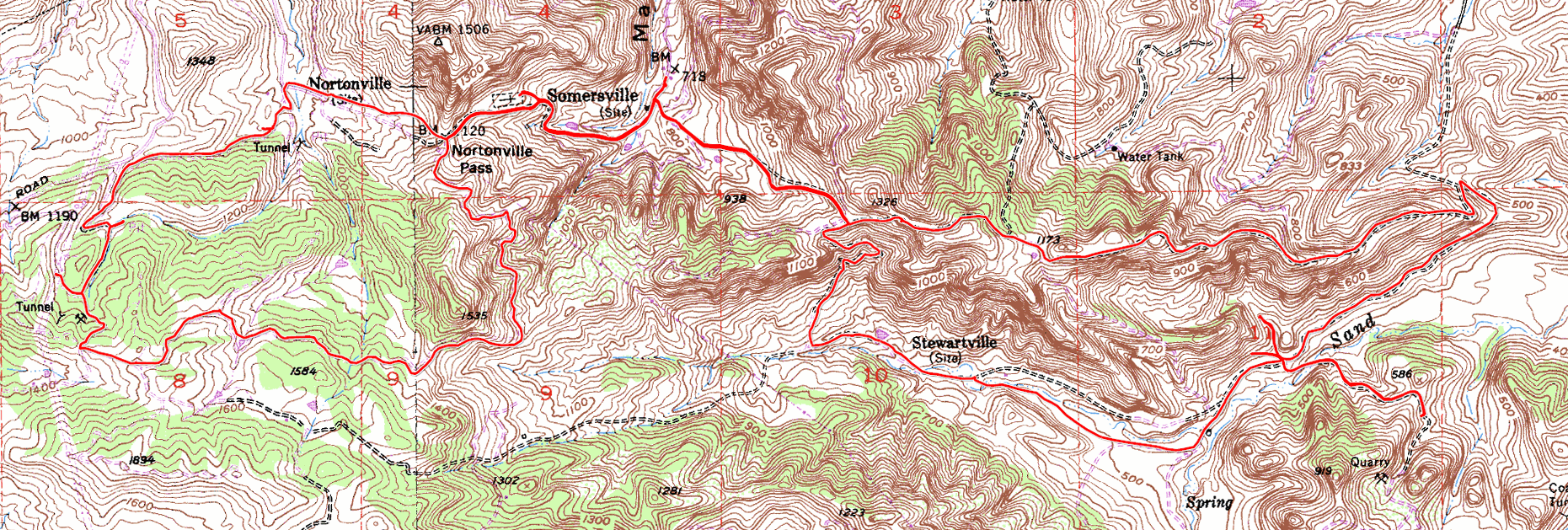
Black Diamond Mines Regional Preserve encompasses an area that used to be the largest coal mining district in California during the second half of the 19th century. The park contains 12 coal mines and the sites of what used to be 5 towns (okay, maybe "villages") that were supported by them. Today, the only things left to be seen are piles of mine tailings, some mine entrances, the flattened foundation sites of some buildings, a reasonably intact cemetery, and (reportedly) some railroad beds. It might seem surprising at first to see that not a single plank of wood of any building from the coal mining years remains today, at least until it's explained to you that it was common then for folks to disassemble their wooden buildings and take the materials with them when they moved away from a spot. You can actually take a guided tour of a mine at Black Diamond Mines, albeit not of a coal mine but of a sand mine. Hazel-Atlas Mine was used for the extraction of sand suitable for glass production in the first half of the 20th century. The website of the park states that tickets for a 1.5-hour guided tour of this mine can be purchased (for $5 per person, as of this writing) at the Greathouse Visitor Center near the mine. In terms of mountain biking, what the park offers is not too different from many other East Bay parks: Only fire roads are legal, the terrain is hilly, the scenery is idyllic when the grass is green and arid when it's yellow, most climbs are steep, and views occasionally open up from hilltops to surrounding valleys and parts of the bay. One additional thing offered by Black Diamond Mines is the historic interest it holds. Those of you who like "bike-based exploration" might get the most kick out of this one. This ride starts from the parking lot near the Somersville town site. Basically, this is the farthest point you can reach by car when you enter the park via its main entrance. There is a $5 entrance fee (as of this writing) that you need to pay as you enter the park this way. This is collected at a staffed toll booth. I'm not sure what the practice is in terms of paying the fee if you enter the park when the booth is unattended, or even if you can. The ride route consists of two fairly independent loops. If you take this to mean that it's a good idea to tailor the ride to your liking by doing only one of the two loops or both of them together, you'd be correct. There are enough steep climbs on these trails that doing either loop by itself still wouldn't be a bad workout. Incidentally, if you'd like to avoid as much of the serious climbs as possible, I would recommend the eastern (first) loop of the ride. Meanwhile, if your main interest will be in the traces of the mining past of this region, then you should know that the western (second) loop holds a noticeably higher number of things to be seen. The first 0.75 miles of the ride climbs the "stem" of the first loop, on Stewartville Trail. The grade of this climb probably averages somewhere around 9%, except for its last stretch that's more like 15%. Once that's over, Ridge Trail greets you with a single very-steep initial burst (exceeding 20% grade), after which it starts following a ridgetop mostly flatly or while slowly descending. Along the way, you pass an intersection with Corcoran Mine Trail, which descends from the ridge to the valley floor more directly. This trail is the closest thing to a legal singletrack trail that I know of in this park. I've never tried it. However, a couple of users who added comments to this page below describe a very steep and rocky stretch of this trail near its bottom that would be treacherous for most riders. So, beware. As you descend along the ridgetop following the route shown on this page, views are available to the Delta and the Central Valley. Ridge Trail follows precisely the spine of a fairly narrow ridge for most of its second half. This segment constitutes easily the most scenic part of the whole ride. You not only get some views that look like they might belong in an airplane's window, but the fast and twisty descent toward the end of the ridge will have you looking down at expansive scenery on both sides. This is a pretty memorable stretch. As you start heading west on Stewartville Trail, you'll initially find yourself alternating between riding flatly and imperceptibly descending on your way through the valley. You'll notice that there is a spot on the route plot where two spurs go off the main loop in opposing directions from the same spot along this part of the loop. (There's also a third, short spur here, but that was merely to check out a small quarry-like spot just off the trail and isn't worth much attention.) The shorter of the two main spurs here, which heads north, is a 1500-foot hike up to Prospect Tunnel. This tunnel is described as a 400-foot-long tunnel dug in the 1860s to look for coal. You can walk as far as 200 feet into this tunnel. It's the only mine tunnel in the park that can be freely entered by the public. If you'd like to try your hand at this (and you might want to see the photos of this ride in order to decide), you'll need to bring a flashlight with you; not to mention possibly a bike lock to secure your bike to a nearby tree while you take the hike. The longer spur on the other side takes you to the entrance of Star Mine. This is described on the park map as one of the last active coal mines in the area. That description might get your hopes up, but you still don't get to see anything here more than a narrow, barred-up mine entrance through which you might be able to peer. (Again, check the ride photos for yourself.) This side trip will cost you an extra 1 mile in riding distance and about another 250 feet of elevation gain. Continuing along the loop, you'll soon be passing by the Stewartville town site. There's nothing to see there except an interpretive signboard and a pile of tailings from Central Mine. Shortly after that, the route takes a sharp right turn and has you heading toward one of the challenging climbs of this ride. As the fire road climbs back to the intersection where you started the loop on Ridge Trail, it takes a few wide switchbacks where the grade averages around 13%, but, more importantly, frequently exceeds 20%. This whole section is no more than half a mile in length, though, so it's no big deal to simply walk it. The route takes you almost all the way back to the parking lot before starting the second main loop. This second loop starts with a climb on Nortonville Trail that can be seen even from the parking lot. If you get the impression that it's a steep one when you see it from there, that's because it is. This climb to "Nortonville Pass" is a hair under half a mile in length, but its overall average grade is 13%, while temporarily exceeding 15% grade in at least a couple of spots. The good news is that you'll have a good excuse to break up this tough climb into two: Rose Hill Cemetery is just off this trail on your way up and it's arguably the most interesting historic site in the park. This cemetery contains dozens of well documented graves with their headstones preserved. Most of these date from the 1870s and some of them can be seen in the photo set linked on your left. You'll be looking down at the Nortonville town site as soon as you complete that tough climb. The trail descends into this somewhat-bowl-shaped area with a fast descent that is even steeper than the climb that you've just completed. If you have any interest in the history of the location, though, don't make the mistake of blasting down this descent in the blink of an eye, because this half-mile descent is the place from which you'll get the best views of the Nortonville town site. It's not like you'll be spotting any buildings; there really aren't any that remain. However, piles of mine tailings can be seen everywhere, a slope climbing up the opposing side of the town site seems to be "pockmarked" with what must be the flattened foundations of numerous homes, and the generally jumbled topography and multiple converging paths in the area make it fairly obvious that there was quite a bit going on around here at some point. Meanwhile, a couple of well placed information panels in the area contain enough historic photos to aid you in recreating an image in your mind's eye of this vanished settlement around you. The end of your descent into the Nortonville town site marks the beginning of the last long climb on the ride. It all begins when Black Diamond Trail passes its junction with Coal Canyon Trail. You are initially slapped by a short climb whose grade reaches nearly 25%, before you settle into a quarter mile where the average grade stays a touch above 15%. The numbers do settle back into a range between 5% and 12% for a good distance after this, but not without another couple of spots reaching up to 15% thrown into the mix. This is also the part of the ride where you'll cover 0.7 miles on a paved trail. This paved mileage includes some of the most moderate slopes of this climb, but it also includes a brutal 800 feet or so (of distance) where the grade averages 18.5%. The climb ends exactly where you finish this paved segment. That last long climb also involves a relatively high density of places to be seen. I've visited three spots there, each of which will be noticeable as a tiny spur off the route plot you see on this page. First to arrive are the remnants of Black Diamond Shaft. The main thing here is what remains of some support structures built of brick, currently broken and partially covered in moss. My second stop on the way up was at "Jim's Place". You'll need to head roughly 200 feet into the hiking-only Coal Canyon Trail (simply walk your bike) to see this tiny dwelling carved into the living rock, situated at the foot of a picturesque oak tree and looking strikingly like the remnant of a half-finished hobbit hole. My last side trip on the way up took me a few seconds into Cumberland Trail to see what the park map labels as an "air shaft", though its appearance from the outside is not unlike the Prospect Tunnel that you see earlier on this ride. Once you leave pavement behind, the remaining part of the route is essentially a descent, though you still don't get to complete this second loop without muscling through another quarter mile of strenuous climbing (15+ percent grades). The early part of this descent takes place in the highest elevations of the ride, so nice views are, once again, common around here. Around the highest elevations, Suisun Bay and the Delta are visible. A little further down, the trail nicely skirts around the head of a wide and shallow grassy valley that is quite pretty. After you swing left and away from this nice valley, that last remaining bit of climbing takes you to the other side of this ridge and back down into Nortonville Pass, from which you'll essentially glide back to the parking lot. © Ergin Guney
Comments: blog comments powered by Disqus |