 |
| What's New | Links | FAQ | Contact |

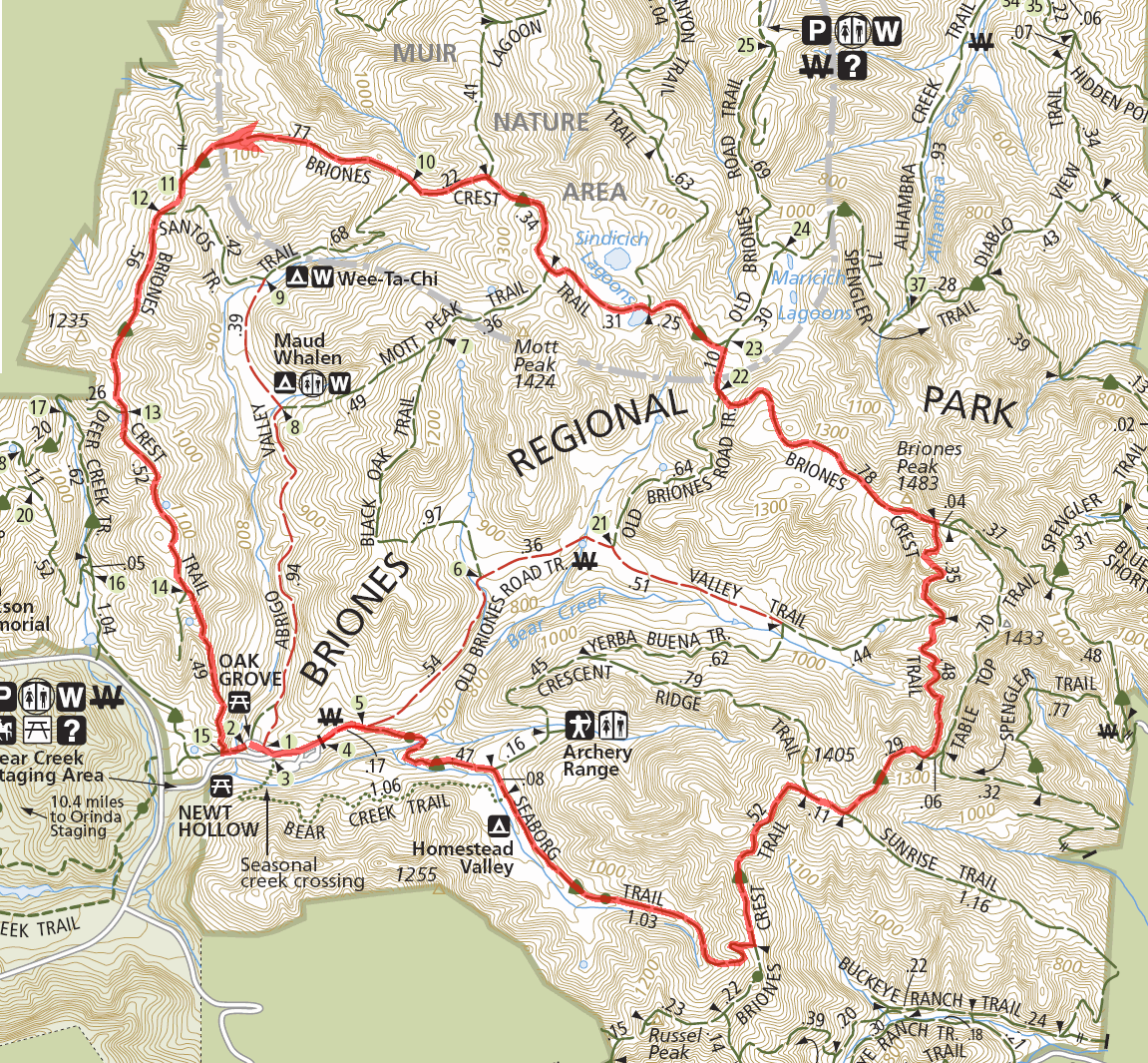
GPS Track Suggested Parking Park Map: Highlighted Original (PDF) Topographic Map Park Website Photos |
Briones (Suggestion 1) 7% SINGLETRACK89% FIRE ROAD4% ROAD 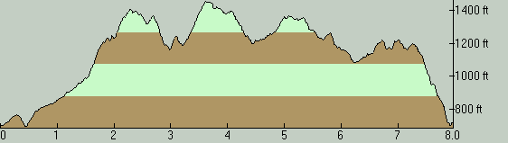
THE PARKBriones Regional Park is a decent sized open space area not far from Walnut Creek. It contains many miles of trails, the vast majority of which are fire roads. For the most part, only the fire roads in the park are legal for bikes. Other than a few tiny stretches of pseudo-singletrack created here and there due to fire roads being narrowed by vegetation, the only bike-legal trail segments I can point out with any level of confidence as singletrack at Briones are Blue Oak Trail, which I haven't tried, and a short segment of Briones Crest Trail that comes as a reward at the very end of this particular ride. As with most fire roads in the East Bay, the climbs in this park can be very steep, usually for no apparent good reason. I often attribute this to the fact that most of these fire roads must have been old ranch roads built based more on practical need than any kind of concern for maintaining a judicious grade. Despite the steepness of the trails here, you won't find any long climbs at Briones. Most serious climbs peter out in less than two miles. Then again, a few of the ultra-short slopes can be so steep that they'll make you shake your head in wonder. Like most East Bay rides, this area would be most enjoyable during the season when the grass is green (roughly between January and April). That time of year, this whole region looks like one giant lawn. Even when done against a backdrop of hay-colored hills, though, rides at Briones can be pretty scenic. The landscape is pretty, with a picturesque mix of cute valleys, rolling hills, and a combination of grassland and wooded patches that almost seems to have been painstakingly arranged purely for variety. From many ridgetops, you also catch views stretching across Suisun Bay toward the Delta or into the upper reaches of San Ramon Valley and to Mount Diablo. Parking inside the park is subject to a fee. This fee is $3 as of the last time I've ridden here. There is a toll booth as you enter the parking lot, where an attendant is present. I'm not aware of any self-pay method for the times when the attendant isn't there. Use of the parking lot appears to be free when the booth is not attended, as far as I know. Those of you who'd rather evade the parking fee may want to know that there is a moderate amount of roadside parking available on Bear Creek Road immediately adjacent to the entrance of the park's very short driveway, and that parking there seems to be tolerated. (But, don't attempt to invoice me if you get ticketed or towed!) THE RIDEThis short ride is essentially a "Briones Crest Trail ride", since it follows this particular trail for three quarters of its total length. Since the ride mostly follows along some of the higher points in the park, views periodically open up in various directions. While the first half of this route provides some decent views toward Mount Diablo and its surroundings, the best views are available only in the second half of the ride and face mostly the north and northeast. As I mentioned above, this route features a short (half-mile) segment of singletrack in the mix. My decision to do the ride in the counter-clockwise direction was solely to be able to descend this singletrack segment at the end. This does mean the toughest climbs of the ride arrive in the first half. The fact that the singletrack is at the very end of the ride feels appropriate, a bit like saving the best for last. Though I don't want to oversell that short section either. It's over very quicklly and is not necessarily the kind of singletrack that dreams are made of. But, still, it's a bike-legal singletrack segment at Briones, and that says something. By the way, this short singletrack decent gets significantly steep at one particular spot and I've witnessed inexperienced riders being (justifiably) intimidated by this. So, if you're less-than-confident on steep descents, you've been warned. Otherwise, though, this singletrack segment is not at all technical, and neither is any other part of this ride. After a brief stint on the park's paved driveway and passing through a gate, you first hit the dirt on this ride on Seaborg Trail. This trail gives you your very first taste of a steep climb when the first half mile of the ride is barely over. Over a stretch that's not even a quarter mile in length, the maximum slope reaches up to 15%. After that, the more consistent portion of Seaborg Trail starts mellow and continues to climb for quite a while at a very mellow grade. This is essentially the last part of the ride about which this can be said. In the final stretches of Seaborg Trail, things change radically. It's almost as if the trail decides to try breaking you when it still has a chance. In its last quarter mile, the trail becomes progressively steeper, finally topping out at a grade of about 25% just before it connects to Briones Crest Trail. And, unfortunately, that's not the last time you will be contending with slopes north of 20% on this ride. While Briones Crest Trail mostly follows a line of ridge spines and hilltops as its name suggests, one stretch of it about 0.8 miles in length in the first half of the ride actually breaks that pattern. In this segment, the trail dips down considerably to weave in and out of the side slopes of a ridge and then climbs back out again to the top while another trail, Table Top Trail, continues along the ridgetop to reach the same spot, as you would expect the "crest" trail to do. This ride follows Briones Crest Trail through this dip and rise. The down side of this is that the climb back out of this segment is the ride's single toughest climb. Over the 0.3 miles that you cover in that stretch to reach the ride's highest point, you average 15% grade end to end. On the positive side, this segment is a nice break in that it feels more sheltered and cozy, which is different from the spacious and bare (though scenic) feeling of most of the rest of the ridgetop mileage on this ride. Plus, this is a rare segment of Briones Crest Trail that occasionally feels almost like a singletrack, if only due to the narrowing down by vegetation. If those advantages may not be enough of an enticement for you, you might want to follow Table Top Trail around this segment, because it involves less elevation change and appears to do it significantly more gently. Around the 4.5-mile mark from the beginning of the ride, there is a marked change in the scenery. Here, Briones Crest Trail opens up toward the northeast, over rolling grasslands sloping down toward Martinez and the Delta, with a handful of small ponds in the foreground. This is arguably the prettiest part of the ride. You ride for about a mile while exposed to this great scenery. As you leave that scenic stretch beings, one more climb on Briones Crest Trail begins. It starts at a moderate slope, but gets steep toward the end of its half-mile length (topping out at about 13% grade). If this feels like it's not boding well for the remaining miles on the ride, it's misleading. This is possibly the last climb on the ride that one might complain about. Things get more breezy past this point. You continue to lose elevation over the rest of the ride and the uphill efforts are shorter and relatively reasonable. This part of the ride is quite fun, when you get multiple chances to swoop down into a dip in the trail and carry nearly enough momentum to make it up the other end, all the while being accompanied by the scenery of the surrounding countryside. The route ends with the short singletrack segment I've already described. Briones Crest Trail enters an unbroken plunge in this portion that takes you practically back to the parking lot. You simply need to turn left at the bottom of the descent and then take the staircase you'll see on your left to get back up to your car. © Ergin Guney
Comments: blog comments powered by Disqus |