 |
| What's New | Links | FAQ | Contact |

GPS Track Suggested Parking Park Map: Highlighted Original (PDF) Topographic Map Park Website Photos |
DeLaveaga Park 90% SINGLETRACK8% FIRE ROAD2% ROAD 
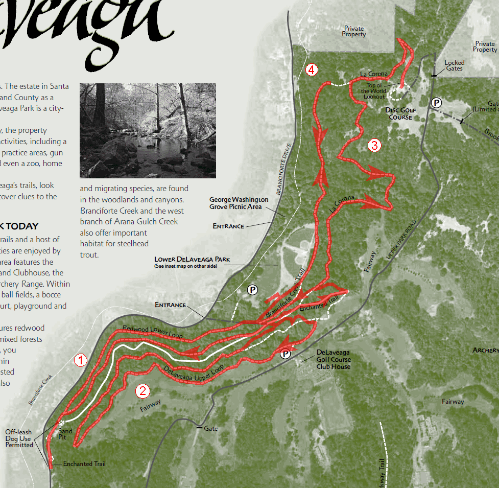
DeLaveaga Park is a small Santa Cruz city park with something on the order of 10 miles of trails open to biking. Considering the fact that all of this trail network is pretty much limited to a single hillside, it's a respectable amount actually. Almost all of the trails are singletrack, sometimes technical, and fun. No one would expect this little park to be a destination for bikers from distant places, but it's an enviable option for short rides for the locals. Still, I've never regretted even driving down here all the way from San Francisco when I'm in the mood for some less familiar singletrack and not looking for a very long ride. DeLaveaga Park is not exactly tiny, but almost all of its trails are packed into one narrow slice of the park: all noteworthy trails in the park are stretched across (and are confined to) the fairly steep, densely wooded, southern hillside of the canyon of Branciforte Creek, just before it flattens out considerably as it opens up to the coastal plain occupied by the city of Santa Cruz. All of these trails follow a mostly flat profile, shuttling back and forth along the hillside. Any climbs are either very gentle or very short. What's even better is that I know of no trails in the park that disallow bikes and that the vast majority of these trails are narrow singletrack. The singletrack at DeLaveaga is typically only mildly technical, just enough to keep experienced riders reasonably entertained, though there are a handful of notable trail features that take some serious skill to negotiate. Given the modest amount of trail mileage at DeLaveaga, any substantial ride you do here is likely to cover almost all the available trails. That is what the route shown on this page does as well. You don't need much advice in order to put together a decent ride route at DeLaveaga. There aren't too many route options that are clearly preferable or any big pitfalls to avoid. So, the particular ride on this page is not meant as a route to be followed precisely; it's merely one possible way of putting together most of the trails in the park. For that reason, what I'll do is merely list some notes about the trails. La Corona Trail is probably the closest thing in the park to a main thoroughfare, at least when put together with Enchanted Trail. It stretches for 1.5 miles from near the park's main parking lot all the way to the highest point in the park's trail network, the vista point labeled "Top of the World" on the park's trail map (whose views are worth a stop but are not really spectacular). Much of this climb has a gentle slope, averaging somewhere around 5% grade. Near its upper end, the trail maintains grades around 10% for longer periods. The trail is often in the form of a wide singletrack, but some parts are moderately narrow. There are a handful of techy trail features on La Corona that used to be the spots where some serious attention was called for, but most of these places seem to have been widened lately and now have easier bypasses. Still, this trail is a must-have for any ride in this park; it's an easy climb on the way up and is a descent that maintains good flow on the way down. Despite its fancy name, Enchanted Trail is easily the least interesting trail in the park for a mountain biker. This is a smooth fire road with a gentle slope. With its nice tree cover, it makes for a pretty enough forest stroll, but it doesn't have much to offer a biker (other than an additional connection option) when compared to the nice singletrack options that parallel it. Redwood Lower Loop and DeLaveaga Upper Loop are narrow singletrack loops that follow extremely elongated shapes and are very similar to each other. It's just that Redwood Lower Loop sits on flatter terrain while DeLaveaga Upper Loop snakes along a steep hillside and its upper half skirts along the edge of the DeLaveaga Golf Course for a little while. Stretching on either side of Enchanted Trail, these two loops comprise the singletrack riding options in the southern half of the park's trail network. At its southern tip, Redwood Lower Loop connects to Enchanted Loop again, which can take you to a playground-like area labeled "sand pit" on the park map, if you continue following it downhill for a few more seconds. Branciforte Creek Trail is another singletrack that heads north from around the main parking lot, this one doing it mainly along the foot of the hillside. It squeezes through relatively dense vegetation and dips into a stream bed or two along the way. Shortly after reaching a clearing dominated by the large limbs of an old oak that hangs over it, this trail suddenly starts a very steep climb (possibly the park's steepest) as it turns to head toward the junction where its northern end meets La Corona. © Ergin Guney
Comments: blog comments powered by Disqus |