 |
| What's New | Links | FAQ | Contact |

GPS Track Suggested Parking Topographic Map Park Website Photos |
Monterey Bay Coastal Trail 97% PAVED3% ROAD 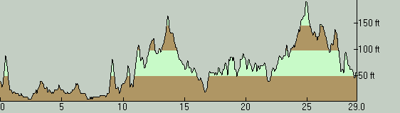
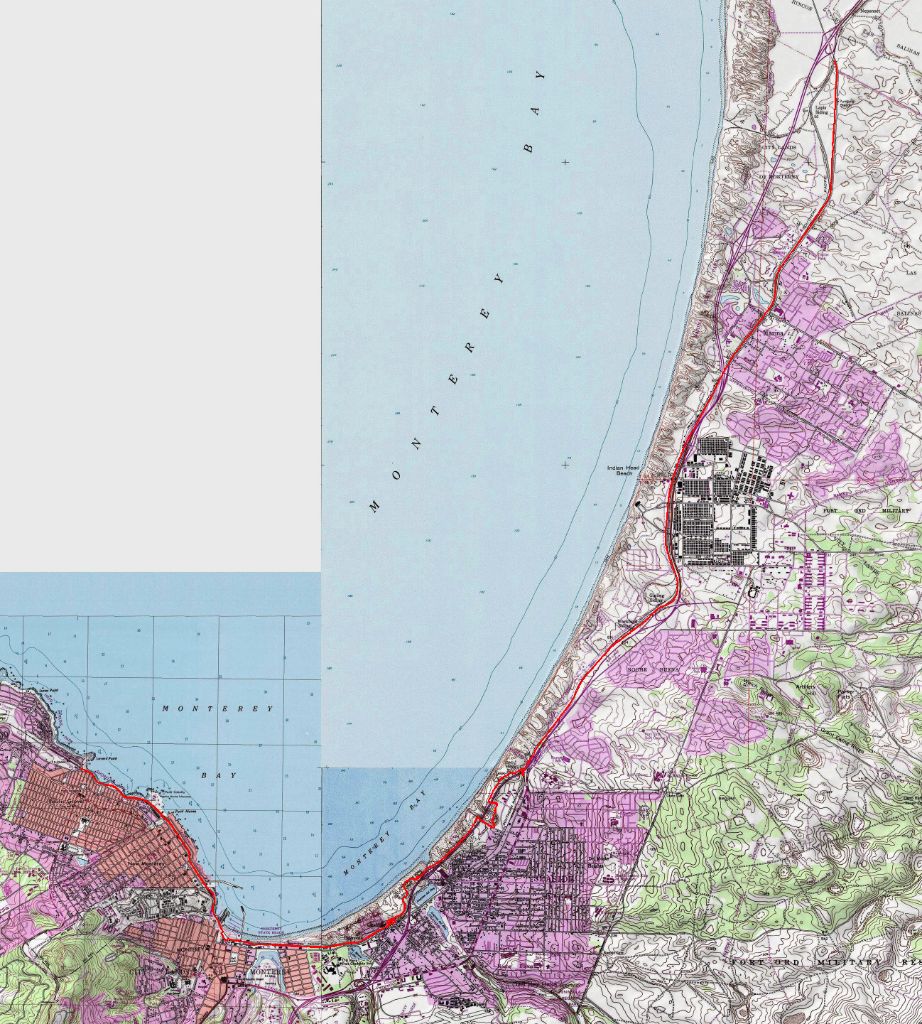
This is a casual ride that could easily rank among the top three of its kind around the Bay Area in terms of ease and scenery, as well as length. The setting of the ride ranges from the nearly deserted expanses of Salinas Valley, past the wide beaches of Monterey Bay backed by dunes, all the way to the thick of the tourist areas of Monterey and Pacific Grove. When traversed end-to-end, the ride should constitute a reasonable option for a mild workout to cyclists who live nearby. Most casual riders, on the other hand, will probably find the western part of the route of most interest, which could be a draw even for residents of distant towns who are looking for a low-key, casual ride to use as an excuse for a nice weekend outing on the coast. For riders interested more in scenery and casual fun than a workout, it will probably make more sense to continue the ride further into Pacific Grove rather than turning back from where I did. The traffic in Pacific Grove is fairly sane and calm, as far as I've seen, and riding on streets after reaching the end of the trail should be reasonably safe. Especially in that latter form, this is an ideal ride to be done unhurriedly and just for the sheer joy of it. What's on offer are enticing rest stop possibilities for food or treats in the heart of Monterey and sightings of wildlife including seals, sea otters, not to mention a whole variety of sea birds. You get really close to the water somewhere around the Monterey marina and, although the trail follows what feels like a back street that parallels Cannery Row as it passes through the densest tourist areas, before and after that portion it follows right on the coast and it's directly open to the picturesque Monterey Bay. In addition to the views and treats, the route also allows you to catch sights of some of Monterey's and California's most historic buildings, as well as passing right by the Monterey State Historic Park at the city's historic core. This is a ride that you want to do on a day with nice weather, which is unfortunately pretty difficult to ensure in this area. Your best bet of being confident of finding a sunny and pleasant day here might be in the fall or perhaps in an exceptionally cool and clear day during the winter. By contrast, during much of the summer, this part of the coast is notorious for being cloudy or foggy and cold, while locations further inland are sunny and balmy. You have been warned. What I've done here really amounts more to a mapping out of the entire length of the trail rather than doing what a typical ride on this trail would look like for a typical rider. The ride is in the form of two separate out-and-back spurs from the midpoint of a single long trail and the character of the two halves are unsurprisingly very different from each other, given their very different settings. The part that heads into Monterey and Pacific Grove is crowded and all about pretty sights, people watching, and excuses for rest stops. Meanwhile, the part heading north is much less densely used and is all about covering distance without much impediment. The farther north you go, the more the trail becomes deserted. As you go through Sand City and Marina, you do get a little bit of pedestrian presence on the trail. But once you're past those areas, you'll have the trail almost completely to yourself. A casual trail like this doesn't really need a formal name, but if you were curious as to what it should be called, you'd have a little trouble because the trail is referred to by a number of names across different websites and trail signs. If you're interested, the list includes "Monterey Peninsula Recreational Trail" (on Google), "Monterey Bay Coastal Recreation Trail" (on numerous websites), "Dunes Trail" (on trail signs around Sand City), and even "George J. Takahashi Bicycle Path" (in Marina). Perhaps some of those apply to only limited stretches of the trail. In any case, if I'm forced to pick one name to apply to the entire trail, I will go with "Monterey Bay Coastal Trail" which is a name I've seen repeated on the most authoritative-looking trail signs on either end of the trail's span as well as being used as a secondary name on Google Maps and some websites. The starting point I picked for the ride is a parking lot on Sand Dunes Road, through there are plenty of other options. One option is a second parking lot very close to the one that I used. Other options are a paid parking lot of Fisherman's Wharf in Monterey, a couple of spur streets that head toward the beach from Highway 1 along the ride route, some roadside parking in the part of the ride that detours through city streets, and basically any town along Highway 1 where you can use street parking and make your way to the trail itself. Nearly all of the ride takes place on this paved trail. The only exception to this is a short segment where you need to connect to the rest of the trail by following city streets for a couple of blocks, threading behind a few big-box retail stores. This is not to say that you don't interact with traffic at all over the rest of the route. In fact, the trail crosses streets and driveways numerous times. Although virtually all of these have a yield sign for the users, implying that the crossing traffic has the right of way, during my ride most drivers who saw me actually stopped and waited until I used the crossing. Following the trail is made very easy by a dashed yellow line bisecting it almost throughout the entire ride, with the exception of a portion of the trail in Marina. So, across intersections and plazas, simply look for which way the dashed yellow line is headed and you will know how to proceed. Having said that, there's one junction that I encountered on the southern spur of my ride where it's easy enough to find the correct direction to turn on your way out, because you approach it as a T-junction, but on the way back it's easy to miss unless you're looking out for it because it looks like a left turn as the main trail continues straight. Watch out for it shortly before the nine-mile mark of this particular ride route. The quality of the trail surface is very good. The only possible cause for complaint is the presence of tree roots that cause folds in the pavement in a few places. These aren't prevalent enough to become a real problem, but they're frequency is enough to make them noticeable. In fact, one or two particularly bad clusters of these were announced at the time of my ride with a sign that read "bump ahead". As you might expect from a trail that closely parallels coastal roads along sandy beaches, the ride doesn't have any significant elevation change, but it does have minor ups and downs as you can see from the elevation profile plot. These are not very serious and inexperienced riders can slowly make their way up and down all of these with relative ease. Meanwhile, experienced riders who are looking for a more beefy workout can utilize these for more serious exertion by shifting to a higher gear and maintaining a relatively high speed. When you start heading north and the trail settles along the railroad track that it follows along much of its length, it becomes fairly set in from the beach and the views of the ocean become very sporradic and distant. And once the trail starts following Del Monte Avenue, any interesting views disappear completely other than those of the nice countryside once you make it past Marina. At one point of the ride before that, you have the option of turning onto Beach Range Road and following that road north along the same railroad that the main trail parallels. I observed that this is a fairly popular option for the users of the trail at the time of my ride. Beach Range Road is another paved trail. It doesn't reach as far as Monterey Bay Coastal Trail does, but you can follow it for about four miles until the doorstep of Marina. If you notice that the trail passes by some dunes very closely, you might be concerned that sand might encroach onto the trail surface to make things inconvenient. In fact, having picked a date for my ride that followed two relatively stormy weeks, I was especially concerned about this and was actually on the verge of changing my mind about doing the ride on the particular day that I did. In fact, when I checked Google Maps imagery before my ride, I saw that a few spots of the trail could be seen with sand overlying them. However, my fears were unfounded. I was expecting to have to shoulder my bike and walk across several stretches of the trail during my ride, but that didn't happen. There was really only one substantial stretch where there was a significant amount of sand on the trail, but it wasn't enough to make it unrideable at all. © Ergin Guney
Comments: blog comments powered by Disqus |