 |
| What's New | Links | FAQ | Contact |

GPS Track Suggested Parking Park Map Topographic Map Park Website Photos |
Pacifica 18% SINGLETRACK28% FIRE ROAD52% PAVED2% ROAD 
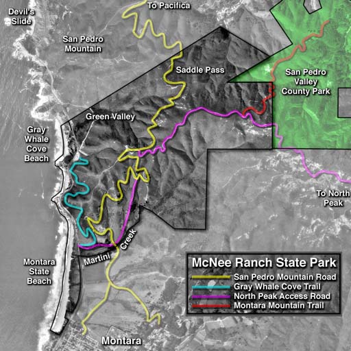
This ride puts together a decent amount of fire-road and a little singletrack riding in an area that, I'd say, doesn't have huge amounts of either one. The ride climbs from Pacifica to halfway up Montara Mountain where it forks. Depending on whether you do one of the prongs at that fork or the other, you can vary the ride's difficulty from beginner level to fairly strenuous. One note about parking, first: You need to know that the stretch along Higgins Way shown on this page as the suggested parking spot features "2-Hour Parking" signs. So, if you expect your ride to take two hours or less, you shouldn't have a problem parking there. If you'll be taking longer, you will need to look for other street-side parking without this restriction. You should be able to find something within a couple of blocks, such as around the intersection with Adobe Drive and Peralta Road, or a little further down the hill. It might be worth clarifying one point: Seeing that I classifed more than half of this route as a "paved trail" in the trail type breakdown, don't get the impression that most of this ride is on a family-grade paved recreational trail. That paved mileage is the portion of the ride on Old San Pedro Mountain Road that still retains most of its asphalt pavement from the days it used to be a public road. While this pavement is narrowed, washed out, and sometimes completely peeled off on many patches along this trail, I still felt that it would be more of a stretch to classify this portion of the ride as a "singletrack" or as a "fire road". The initial climb on this ride starts Old San Pedro Mountain Road. As I've just mentioned, this is currently a park trail topped with old pavement that's crumbling in most places and has completely disappeared at a number of brief segments. In an earlier life, this road seems to have been one of a few roads used historically as the main coastal thoroughfare along this segment of the Peninsula before Highway 1 was built. Possibly owing to this, its grade is very tame. The first mile you ride on this trail averages a grade of a little over 4%, and the remaining 1.5 miles to Saddle Pass averages just under 6%. There's close to a mile of equally gentle descent right after that, as the partially washed-out and overgrown road (now effectively a singletrack trail) descends along the folds of a hillside. When that gentle descent ends at an intersection with North Peak Access Road on a ridgetop, you will be at the main decision point of the ride. From here, the route shown on this page initially descends further on Old San Pedro Mountain Road to Gray Whale Cove Trail and doubles back to this same intersection after traversing the entire length of Gray Whale Cove Trail. It then heads uphill on North Peak Access Road from here to climb all the way to North Peak, before returning to this junction one last time on the way back to the very beginning. If you are looking for an easy ride that can be done even by beginners, do only the Gray Whale Cove prong of this fork and head straight back to your car when you return to this junction. If you are up for a stiff workout but don't have time for all 17 miles of this route, then do only the North Peak prong and head back from this junction. If, however, you have both the time and the energy and you'd like to see it all, doing the entire route as shown on this page shouldn't disappoint. As you head down to Gray Whale Cove Trail, you'll be descending, once again, on a trail with a crumbling paved surface. This is the continuation of Old San Pedro Mountain Road. The descent is about 1.75 miles in length and maintains that same gentle grade that doesn't even reach -6%. The good part of this is that you'll have an equally easy grade when you're climbing back up this stretch. This semi-paved portion is wider than any of the other trails with pavement that you've traversed up to this point on the ride, though. Except for watching out for spots where the trail is seriously narrowed by small slides, there's little to do on your way down this stretch other than a fast and smooth glide all the way to the connector to Gray Whale Cove Trail. On the positive side, you'll be facing very nice views of Montara and Moss Beach as you do this, though. If you're paying any attention during that descent at all, you shouldn't miss the junction with the connector to Gray Whale Cove Trail, because it has a sign. Taking this connector, followed by another right turn, will set you on the way to the parking lot at Gray Whale Cove State Beach on a dead-end singletrack. This is an almost-level trail that continues along the hillside, varying in form from a narrow fire road to a (sometimes overgrown) narrow singletrack. It doesn't present many opportunities to satisfy any technical biking urges, but it can be a delightful slice of coastal bliss with the sound of the surf on one side and birds chirping on the other. Unfortunately, there aren't any loop options from here. As I've already mentioned, you retrace your path all the way to the junction with North Peak Access Road, once you reach the parking lot at Gray Whale Cove Beach. North Beach Access Road is when the serious part of the ride begins, in terms of pedaling effort. Here, the trail turns plain evil and attains an average grade of 17.5% over almost half a mile as you continue climbing. There are short bursts here during which I'm pretty sure the grade exceeds 30%. This short part of the ride is not fun by any definition of the term. Simply think of it as something you need to get past, in order to get on with the rest of the ride. Including the part where the grade partially slackens but still remains serious, things don't ease up for close to a mile from that ridgetop intersection. But then, they do. The rest of the climb to the peak will still have you working, but it's nothing to whine about. As you get higher, the views slowly become more and more expansive. The scenery northward toward Pacifica and all the way to Ocean Beach and Mount Tam are the first to open up. As you get higher, you catch some southern vistas toward Montara Beach and the Half Moon Bay airport as well. Closer to the peak, you'll start seeing antenna facilities and a tighter network of (dirt) roads and trails due to their presence (presumably). There is also a curious abundance of abandoned car wrecks around this portion of the ride. In fact, you'll notice that the route plot shown on this page reflects a short side trip to see one of these. The views from the peak may not be competitive with what you get to see from Mount Tam or from some East Bay peaks, but, since they're from a 1900-foot peak, they're not too shabby either. Doing this ride on a day that's popular with riders, it was easy to notice that these trails have some regular local riders who know the ins and outs of not just this main route up the mountain, but also a number of side trails and shortcuts. Seeing that, my riding buddies and I decided to sample some of these trails ourselves on our way back down, instead of tracing the same exact route back to the trailhead. You'll therefore notice that our track diverges from the original way we took when we're back near the beginning. This section enters a eucalyptus-covered area filled with some stunts and a singletrack known as Boy Scout Trail. It's really more like a tight mesh of trails rather than a single trail. These trails are quite technical and some descents and turns are fairly steep. But, this makes a nice addition to an otherwise non-technical ride. However, if you're trying to do the beginner-level incarnation of this ride, you should bypass the Boy Scout area and follow Old San Pedro Road all the way back to Higgins Way. © Ergin Guney
Comments: blog comments powered by Disqus |