 |
| What's New | Links | FAQ | Contact |

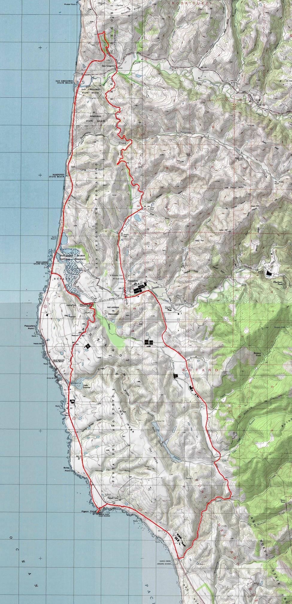
GPS Track Suggested Parking Topographic Map Photos |
Pescadero - San Gregorio Loop 100% ROAD 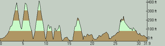
This road ride provides good returns in terms of "scenery per unit amount of climbing effort" and can be made even less strenuous by altering it with two simple tweaks that I explain below. The route includes the relatively busy traffic of Highway 1 and some of the idyllic back roads of the Peninsula coast. The notable points of interest along the ride (not to mention the generally very scenic riding along the entire route) are the tiny town of Pescadero itself, the even tinier San Gregorio, and the Pigeon Point Lighthouse. This particular version of the loop starts from Pescadero. There could be other meaningful options for a starting point, but my intent for picking Pescadero for this was to ensure that the best options for a post-ride meal or other refreshments would be available right there when the loop is completed back in Pescadero. Note that there is an overflow parking lot on the southwest corner of the intersection of Pescadero Creek Road and Stage Road. (The Suggested Parking link on your left marks this parking lot.) The local business owners will be grateful to you if you make sure you park there for your bike ride, instead of occupying one of the street-side parking spots along the business-lined main street that are more convenient for shoppers and restaurant patrons. The ride starts by continuing north along the "main street" of Pescadero (Stage Road). This first stretch of the route is part of the idyllic half of the ride. After leaving the few blocks of "downtown" Pescadero behind, this road becomes an almost-deserted and very pretty country road that passes by some farms and homes, not to mention a cute stretch lined on both sides with tall eucalyptus trees. Stage Road crosses two ridges on its way to San Gregorio. Each of these moderate climbs lasts for around three quarters of a mile and neither are particularly memorable unless you're out of shape. The first climb averages a touch over 5% grade. Once you descend to cross Pomponio Creek, the second climb tests you a little further with a grade slightly above 7%. However, the second climb has a couple of short stretches where the grade exceeds 10%. In the end, though, you'll probably remember the sweet descent toward San Gregorio with the ocean visible in front of you for part of the way after the second climb, rather than how much work the climbs were. San Gregorio is little more than a single intersection with a "general store and post office" on one side and a defunct (and quite picturesque) old gas/service station on the other. Still, it's a natural rest stop for people on sightseeing drives or bike rides along Route 84 as well as on Highway 1. It's worth pointing out that this general store features live music on weekends and makes for an excellent opportunity to kick back a little and possibly mingle with fellow cyclists, as well as carrying some possibly unexpected merchandise such as clothing and books. From San Gregorio, you continue the same way on Stage Road. This last mile of the road is quiet, very lightly used, and scenic. It ends by connecting you to Highway 1, but not before costing you 400 feet of additional elevation gain. This climb is like a little longer version of the second climb you did on the way to San Gregorio in terms of average slope and uniformity. You gain those 400 feet in 1 mile. Those who would rather keep the ride as easy as possible could bypass this "northern tip" of the route by taking Route 84 from San Gregorio to reach Highway 1, as shown on the alternate version of this ride. In addition to saving you nearly all of that 400-foot climb, that will also shorten the overall ride length by about a mile and a half. The initial portion of the Highway 1 segment of this ride (down to Pescadero Beach) repeats a distinct pattern a few times: You climb a couple of hundred feet to the top of a coastal bluff, perhaps catch some ocean views from a roadside vista point, then descend to a small state beach at the mouth of a creek, and then climb the next bluff and repeat. And there's nothing wrong with that. The climbs are not grueling and each beach is a little gem that's worth a brief rest stop, if not a mini picnic. The portion of Highway 1 traversed on this ride features a wide paved shoulder and is, therefore, pretty safe for cyclists. The only exception to this rule are the narrow bridges that cross the creeks that flow onto some of those little beaches, where the shoulder is typically reduced to a foot in width or less, and you are forced to become more intimate with motor-vehicle traffic. Another note about riding on Highway 1 is that general wisdom states it's better to ride southbound than northbound, due to the prevailing winds. This particular ride does not ignore that advice. At the intersection of Pescadero Creek Road, the ride turns inland for a temporary diversion. This portion of the route is simply to use a much nicer, quieter, and deserted back road (Bean Hollow Road) in exchange for the corresponding stretch of Highway 1 that is flat and frankly boring. This comes at the cost of a little more elevation gain though. You incur 200 or 250 more feet of climbing when following this inland diversion than you would on Highway 1. I find this easily worthwhile, especially since most of this climb is very gentle. Those who'd rather stick to the easiest possible incarnation of this ride can still opt to continue straight on Highway 1 instead, shortening the route by another mile and saving that couple of hundred feet of elevation gain as well. The alternate route represents that easier option. After Pescadero Beach, Highway 1 starts following the coast more flatly and the amount of climbing diminishes dramatically. This also reduces the amount of ocean scenery somewhat. Thankfully, though, it's not long before you arrive at the Pigeon Point Lighthouse, which should make for a fun and interesting stop on your ride. Some of the buildings here have been converted to use as a hostel. You may want to spend a few minutes taking a close look at the lighthouse and the fog horn as well as visiting the gift shop. However, as of this writing, the website for the lighthouse states that the structure itself is closed to the public at the moment, though a small museum and a gift shop are open to the public, not to mention guided walks that are usually available daily at 1:00 PM. You will also find restrooms here. After the lighthouse, it's not long before you leave Highway 1 and take to the back roads again, but not without traversing a pleasant stretch where the surf is closely visible from the road. When you turn inland, you initially follow Gazos Creek Road. This is a narrow country road that follows the bottom of a cute little canyon with virtually no traffic. A wooded road ride probably couldn't be prettier than this stretch of the ride even if it took place in an artificially landscaped setting. This is arguably the sweetest stretch of the ride. Following an all-too-short two-mile stretch on Gazos Creek Road, you turn left onto Cloverdale Road. Initially, this road throws another set of climbs at you—this ride's last. For almost half a mile, this stretch of the ride maintains an average grade of 7 or 8 percent and follows it with one last steep (but very short) burst that seems to reach at least 15% grade. As you approach Butano State Park, though, the road becomes mostly flat and starts following a small, flat-bottomed valley. This segment takes you all the way to Pescadero Road, after which you're back at the beginning of the loop before you know it. For a post-ride meal in Pescadero, Duarte's Tavern is the first option that naturally pops into my mind. This obvious choice traces its roots back to the Prohibition Era. The food there is good, and the desserts are great. In case you don't already know, their "signature dish" is their cream of artichoke soup. On weekends, be prepared to have to wait for your table though. If a decent sandwich or some pastries is all that you need, a second option is the Arcangeli Grocery (a.k.a. Norm's Market). Of course, you could also buy any other type of groceries there and put together your own impromptu picnic as well. And if all you're after is some good coffee, you can't do much better than Downtown Local. Their vinyl record collection and the nostalgic curiosities that make up the rest of their decor are worth a look even if you're not interested in any coffee. © Ergin Guney
Comments: blog comments powered by Disqus |