 |
| What's New | Links | FAQ | Contact |

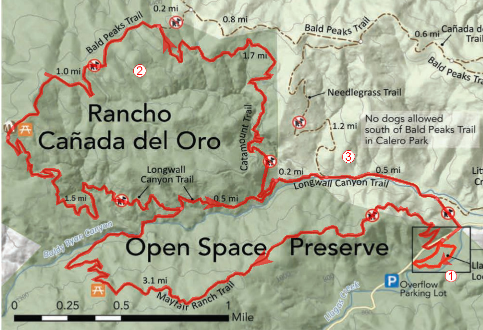
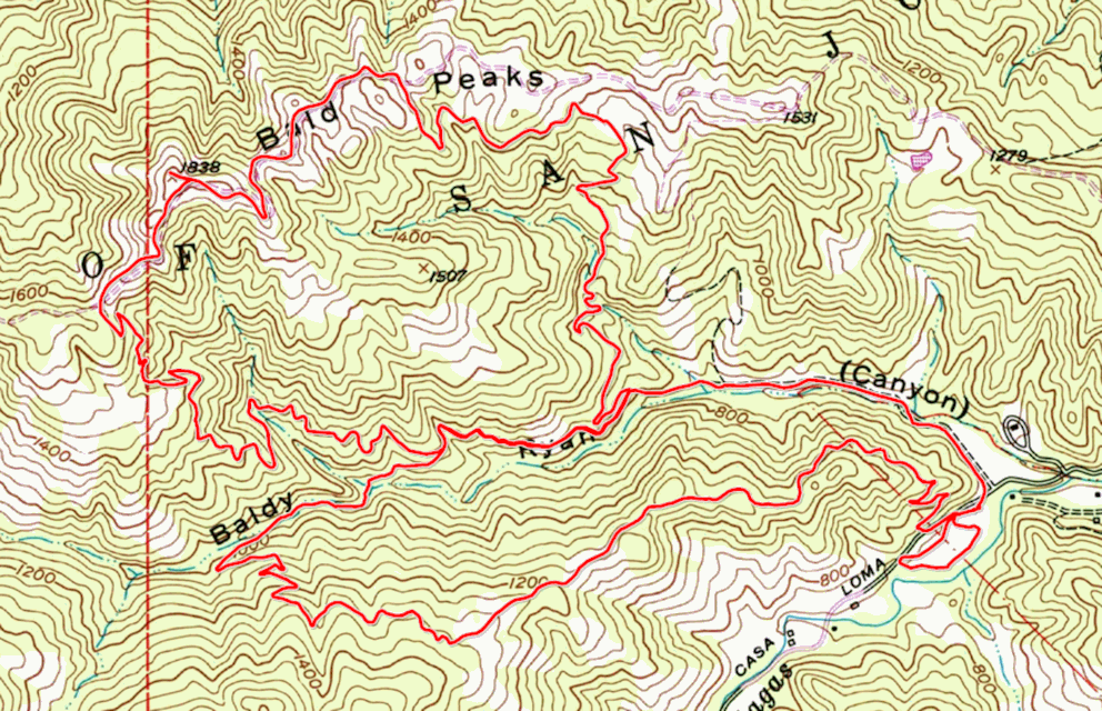
GPS Track Suggested Parking Park Map: Highlighted Original (PDF) Topographic Map Park Website Photos |
Rancho Cañada del Oro 37% SINGLETRACK57% FIRE ROAD5% PAVED1% ROAD 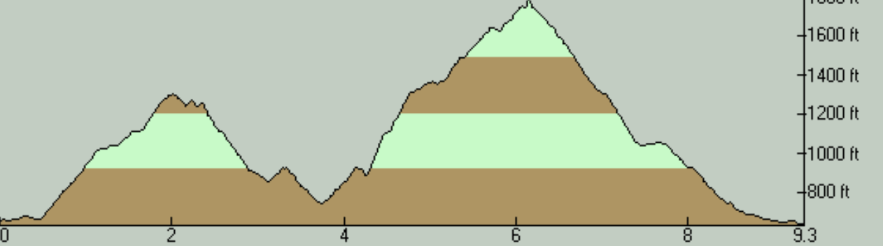
Rancho Cañada del Oro Open Space Preserve is a relatively small county preserve near Morgan Hill. If you add up all the trail segment lengths shown on its official trail map, you get only about nine miles of total trail length (not counting a tiny paved loop). This ride covers all of those trails. If that doesn't sound enough to you, your only option to extend the ride via trail mileage is to extend your ride into Calero County Park. See below for the details of that. This park is one of the lesser-known options for mountain bikers in this area, especially compared to nearby destinations such as Almaden Quicksilver, Santa Teresa, and Henry Coe. The park's website explains that the trails here were opened to mountain biking only in 2007. While it's not a ride location that presents a lot of room for variation, it's still a bit of a hidden treasure as well as containing some passable singletrack. While no one could make a believable claim that the park should be a draw for bikers from distant parts of the Bay Area, it's still a shoo in for inclusion on the "usual list" of ride locations for local riders, in my opinion. The ride takes place around the cute small valley of Baldy Ryan Creek nestled in the foothills of the coastal range, and atop the ridges on either side of it. The setting ranges from bare hilltops that afford panoramic views of the southern reaches of the South Bay, to beautiful oak-sprinkled hillsides that will be doubly pretty during the green-grass months of the year, and to the dense cover of bay trees near the creek bed. The trails are a mix of typical, smooth fire roads and some multi-use trails that I don't mind classifying as "singletrack" though that's mainly thanks to some narrowing down by vegetation over several seasons. This ride begins by following Mayfair Ranch Trail as it climbs up a ridge, follows along its spine for a while, and then descends by some switchbacks toward the creek on the other side. This is one of those multi-use trails I've mentioned above, and the park's website states that it was built in 2007. The initial climb on Mayfair Ranch Trail is a significant climb, though (never exceeding an average of 10% grade) it's not one about which you'd be composing stories of bravery. You can actually avoid Mayfair Ranch Trail altogether, if all that you're interested in is a really short loop to Bald Peaks to take in some views. Note that Mayfair Ranch Trail has been made a one-way trail during the COVID-19 pandemic, so if you are interested in trying it, doing it in the westerly direction (as represented here) is your only option, until this restriction is lifted. As you cross Baldy Ryan Creek over a bridge (along with an option to ford the water, if you feel like it) and reach the junction of Mayfair Ranch and Longwall Canyon trails, you're effectively faced with the primary routing choice that the park's trails give you: You can either do a full loop of the trails north of the creek, or climb to and descend from Bald Peaks over Longwall Canyon Trail and make it into an out-and-back ride. (Doing an out-and-back solely on Catamount Trail would be masochistic and pointless, in my opinion.) What should drive your decision is whether you'll be willing to brave the crazy climb up Catamount Trail. This particular route follows the loop option. If, like me, you prefer to use wider and steeper trails for climbs while you save narrower and more playful trails for descents, then the only meaningful direction in which to do the loop portion of this ride for you will be counter-clockwise. The climb from the creek bed all the way to the highest elevation of the ride (a net change of a little over 1000 feet) lasts a bit over two miles. However, the crucial part of the climb starts around the four-mile mark from the very beginning of the ride, where a 0.15-mile stretch of the trail maintains an average grade of about 24%. After a negligible break, another 0.2-mile section averages nearly 19%. The rest of the climb continues to be a seriously challenging one, but it's never again as prone to make you question your route choice as those two worst segments. Catamount Trail is in the form of a wide and smooth fire road, which is a bit surprising since the website states that it, too, was built in 2007. I suppose even some newly built trails can be in the form of fire roads these days, when they are meant for access by park ranger vehicles. Bald Peaks Trail is another wide and smooth fire road. However, this is one of the most enjoyable portions of the ride due to the scenic nature of this bare trail. Before too long, you take Longwall Canyon Trail from its upper end and this marks the start of the twistier part of your descent—nothing but 1.5 miles of gentle descent through pretty oak woodlands all the way back to the creek bed. From there, Longwall Canyon Trail transforms into a fire road and continues gently downhill back toward the trailhead. Initially, the trail twists as it follows the folds of the hills. After you've reached the same junction with Catamount Trail you had arrived at earlier, Longwall Canyon Trail becomes a lot flatter and straighter as it passes through Calero County Park (whose boundary is clearly marked by a gate). Longwall Canyon Trail includes a couple of easy crossings of minor seasonal streams in its middle region, but its main water feature arrives just before it drops you back onto the park's driveway (Casa Loma Road) where you need to negotiate a wet crossing of Baldy Ryan Creek. This is not a very difficulty creek crossing. I'm not too familiar with how its water volume changes by the season, but it had just enough water to make it a decent practice crossing for less experienced riders during my May ride. The only practical option for extending a ride in this park that I'm aware of is to head into the neighboring Calero County Park via Chisnantuk Peak Trail. To get there, you would turn onto Needlegrass Trail around the 5.5-mile mark of this particular route, shortly before reaching the route's highest point. Chisnantuk Peak Trail branches off Needlegrass Trail very quickly. This trail is a moderately wide singletrack that descends for a touch over 2.5 miles from that point on. Its end-to-end average grade is very mild at a bit over 4.5%, but the slope fluctuates slightly, with the first (highest) mile of the trail being the steepest. But even its supposedly steep segments have a grade of only about 6 or 7 percent. So, adding an out-and-back on Chisnantuk Peak Trail would be a good way of adding a bit over 5 miles and around 700 feet of elevation gain to your ride. And the good news is that the climb portion of this extension will be drastically easier than the worst of the climbs on the core route you see on this page. Of course, you could also continue further into Calero where more than 19 more miles of trails are available to you, most of them singletrack. The catch is that this would add some significant additional climb on Cottle Trail to your extension, part of which is very steep. Refer to the alternate version of my Calero ride description for the details of that. © Ergin Guney
Comments: blog comments powered by Disqus |