 |
| What's New | Links | FAQ | Contact |

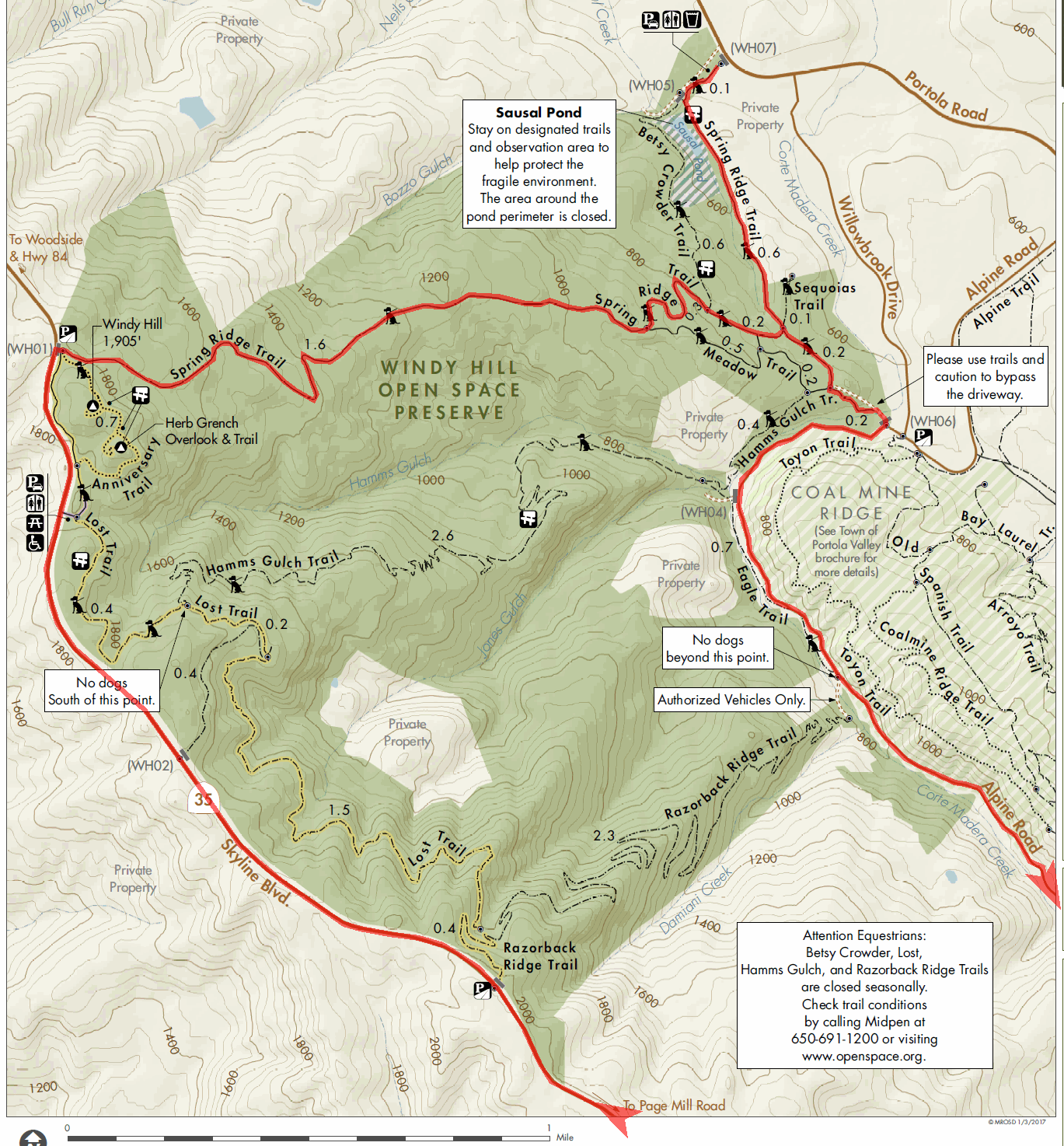
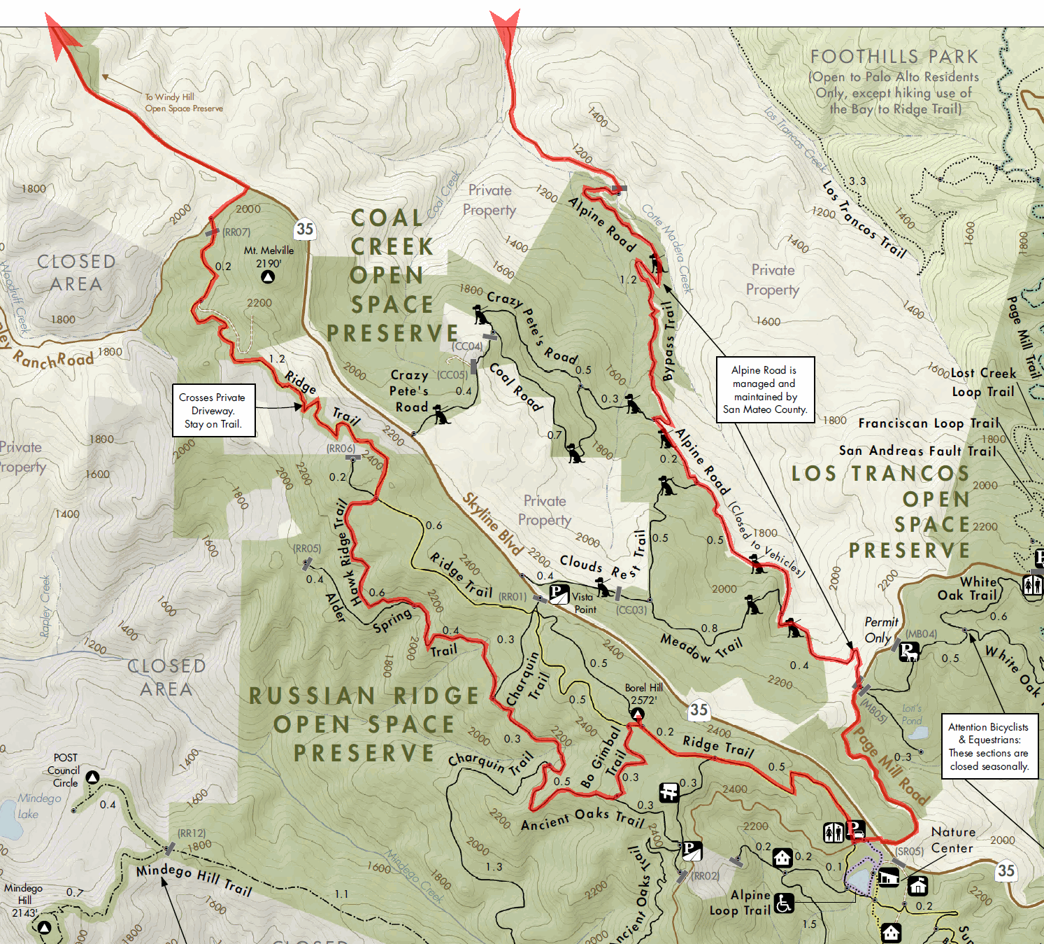
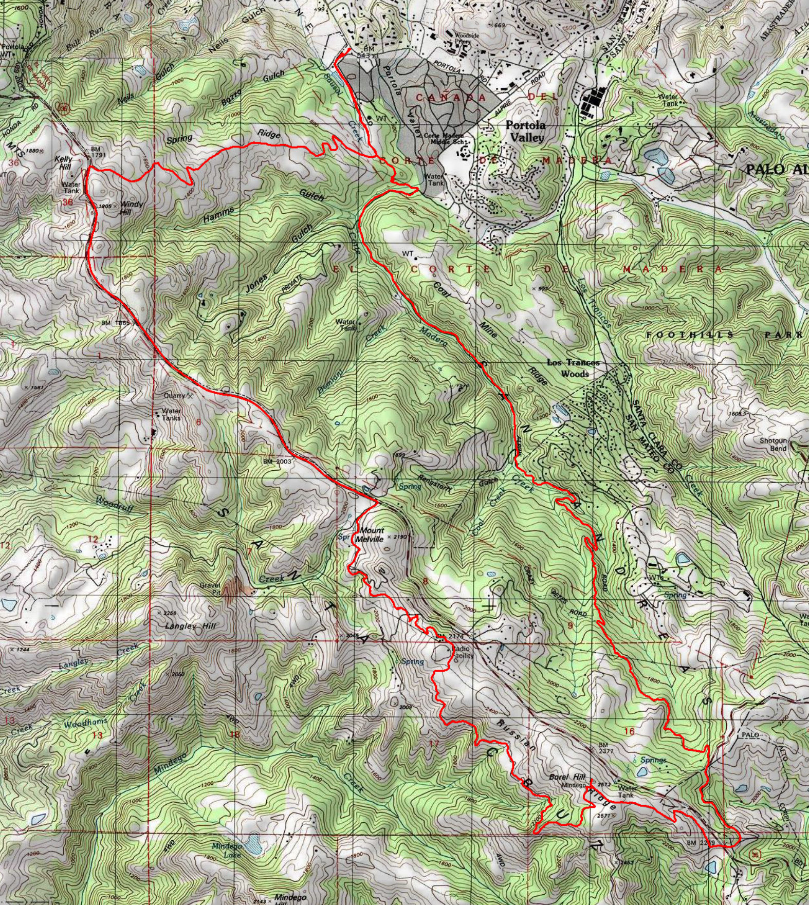
GPS Track Suggested Parking Park Maps: Highlighted: Windy Hill Russian Ridge Original: Windy Hill (PDF) Russian Ridge (PDF) Topographic Map Park Websites: Windy Hill Coal Creek Russian Ridge Photos |
Alpine Road to Windy Hill 21% SINGLETRACK41% FIRE ROAD38% ROAD 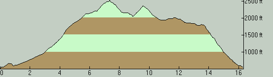
This mixed ride over trails and pavement joins together three open space preserves along Skyline Boulevard, with a short cruise on Skyline itself. This ride (or, more commonly, its shorter version that bypasses Russian Ridge by continuing all the way on Skyline) is one of my favorite weekday-morning rides to do before going to work. That is, at least, for parts of the year when the sun rises fairly early, because the ride is a bit on the long side for a pre-work ride. You park at and start from Windy Hill Open Space. The parking lot of this park is unlocked at sunrise, as of this writing. Parking here is free but the lot does fill up very quickly, especially on weekends. A sign at this lot announces that you can use the parking lot of the Portola Valley Town Center for overflow parking, which is only half a mile up the road. I've also seen cars regularly park on a strip of roadside directly across from the Windy Hill parking lot entrance, but the signage is a little ambiguous about the legitimacy of this. A sign inside the Windy Hill lot clearly says "do not park on Portola Road", while a sign on the actual roadside asks you to "park off pavement", seemingly legitimizing parking there. Perhaps this is to mean that parking is okay on the roadside but they don't want it hogged by park users. A short trail ride skirting the lower boundary of Windy Hill Open Space drops you onto pavement at Alpine Road where the majority of your climb will be done. Alpine Road is initially a public road open to traffic. Then the paved part of the road ends and "old" Alpine Road continues on as a fire road. Apparently, this portion of the road was completely open to traffic all the way to Skyline Boulevard until the 1960s (beyond which Alpine Road is still open to car traffic all the way to the coast even today). Currently, it's effectively a park trail, which local riders call "Dirt Alpine". This is a reasonable fire-road climb. Its steepest section barely reaches an average grade of 8%. There is, however, a short singletrack "detour" section to get around a washout on the main road. This singletrack averages more like 13%, but only lasts for a quarter mile. At the same time, this technical singletrack provides a nice diversion from the steady fire-road climb (even in the uphill direction, with its several steep bursts; though downhill is still more fun, as usual). Dirt Alpine is not a boring and lifeless fire road, though. Many parts of it are narrowed down by vegetation or made more interesting by ruts and erosion (though conditions vary from year to year). It also alternates several times between twisty and straight, as well as between sunny patches and deep shape. All in all, this is a pretty enjoyable fire road to ride. Incidentally, a shorter, out-and-back ride route merely going up and then down this portion of Alpine Road would make for a perfectly pleasant little workout ride in its own right. The one thing you won't find on Alpine Road is a view. For that, you'll need to wait for the second half of this ride route. The climb on Alpine Road ends when you hit the pavement on Page Mill Road. From there, it's an almost-flat road ride for less than a mile to the entrance of Russian Ridge. At this point, you also have the option to turn north on Skyline Boulevard and follow it all the way to Windy Hill in order to save some time, as I mentioned above. You return to trails when you enter Russian Ridge. This portion starts out with a singletrack climb straight out of the Russian Ridge parking lot. This is one of the significant climbs of the ride, averaging around 9% grade for half a mile. Before it ends, you find yourself on a fire road atop a grassy ridge. At this point, Russian Ridge has more singletrack in store but the route visits the top of Borel Hill before continuing onto it, in order to make use of some of the most scenic stretches of this route. Borel Hill has the distinction of being the highest point within San Mateo County, though that doesn't mean that it's an exceptionally high peak; it only means that the higher peaks further south in the Santa Cruz Mountains fall outside the county line. Still, you can see the entire southern half of the bay from here as well as the ocean (when the marine layer allows it), so it's recommended for the views at least on your first time here. The ride returns to singletrack immediately after Borel Hill, by taking you through one of the memorable spots in the park: through a grove of old, gnarly oaks that give the Ancient Oaks Trail its name. The trail surface features more roots here than at any other spot on this ride. Ancient Oaks Trail deposits you onto a fire road again before too long, which takes you to the beginning of the ride's next significant (and toughest) climb on Hawk Ridge Trail. This is another half-mile, singletrack climb. You gain just under 300 of elevation on this climb, amounting to an end-to-end average grade of 9%. The bad news is that there's a short portion near the end of this climb where the grade reaches 13%. The good news is that the trail traverses a steeply sloping, bare hillside that's dramatically exposed to open views of the other hills and ridges between here and the coast. I must add, however, that some spots where the trail happens to be a bit narrow where it's on a particularly steep portion of the hillside may feel scary for inexperienced riders. At the top of Hawk Ridge Trail, you connect back to Ridge Trail, which continues to climb for a few more seconds but then begins an unbroken and fun descent meandering down the northern portion of the ridge. This is quite a playful part of the ride, with a number of switchbacks and a few rocky patches adding to the fun. The trail eventually merges onto dirt roads that ultimately return you to Skyline. When you reach Skyline Boulevard at the other end of Russian Ridge, you turn left and continue north. This segment of the ride becomes pretty scenic as you enter the less wooded areas near Windy Hill. There are spots on Skyline Boulevard, too, where you can see the bay and the ocean at the same time (if the marine layer permits it). Once you arrive back at (this time the top end of) Windy Hill Open Space, you follow Spring Ridge Trail. This is a fire road descent almost all the way to the parking lot. But, the views of the bay in front of you still keep you nicely entertained (that is, if the steeper portions of the descent don't). © Ergin Guney
Comments: blog comments powered by Disqus |