 |
| What's New | Links | FAQ | Contact |

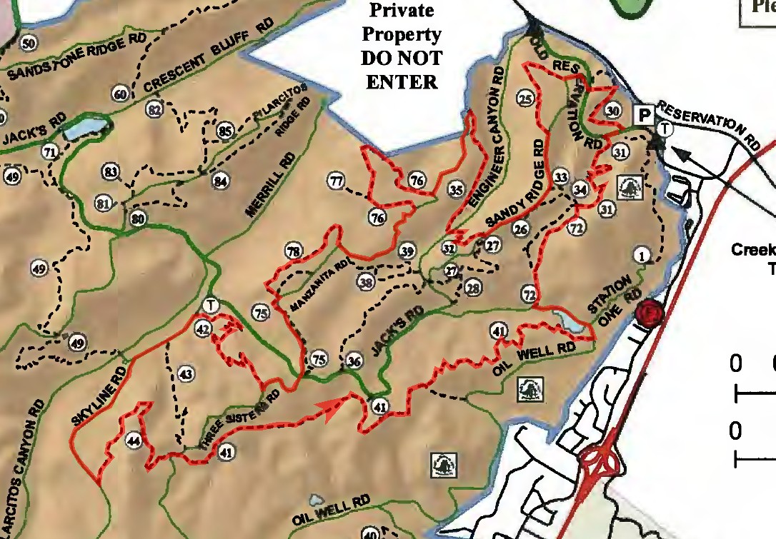
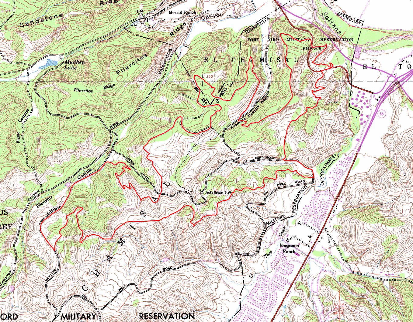
GPS Track Suggested Parking Park Map: Highlighted Original (PDF) Topographic Map Park Website Photos |
Fort Ord (eastern trails) 49% SINGLETRACK50% FIRE ROAD1% ROAD 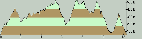
THE PARKSince it used to be a huge military base, it shouldn't come as a surprise that Fort Ord National Monument contains a very large amount of public trails, even though much of what used to be the base is still not open to public use. This large trail network also includes the courses for the bike races organized as part of the Sea Otter Classic, held annually at the neighboring Laguna Seca Raceway. The terrain at Ford Ord does not involve any major mountain ranges, though the mid-size ridges that are present do add up when you string enough of them together. One keyword to keep in mind when riding at Fort Ord is sand. All natural ground surfaces at Ford Ord are sandy at varying levels because most geological features here seem to be mainly of sandstone. Consequently, most trails here are sandy when dry. The best you might expect to find is some form of a thin dusting of sand over a hardpacked surface. The worst spots you'll encounter will be as soft and deep as any beach, making it difficult to make any progress (though spots of this latter type usually—but not always—come and go in seconds). If you have anything other than a sandy surface under your tires at any moment in Fort Ord, either it's one of the fire roads that are artificially covered in gravel or you are on a paved road. So, be prepared for the potential impact of sand when you ride here, including energy-sapping soft trail surfaces, potentially slippery curves, and the risk of hitting a distabilizing sandy patch while traveling at speed. The starting point of this particular ride is the Creekside Terrace Trailhead. Parking is free in this lot. There are actually two parking lots here, one on each side of Creekside Terrace Road. The smaller paved lot is meant for cars and SUVs, and the larger gravel lot on the other side of the road is meant for trailers. The paved lot has space for 26 vehicles, if I'm not mistaken, including disabled parking spots. That's not much. Your only bet if that lot is full seems to be to park in the trailer lot. I don't use this parking lot often enough to know how much that is formally tolerated (so beware), but I saw mostly passenger vehicles even in the trailer lot during this particular ride and not even one trailer. Fort Ord is generally known as a location that is suitable for riding in wet conditions, because the soil is sandy and, therefore, generally drains fairly well. While that is true for the most part, you should know that there are limits to that. I've had one experience where I had to abort a ride here because my bike simply "didn't work" due to the amount of mud sticking to my tires. This was on a morning where the rains had ended only about six hours ago, after a particularly rainy week. Shortly after starting uphill toward Lookout Ridge Road, there were segments where I had difficulty even walking my bike through wet patches because the mud that was piling up behind my chainstays were locking up my rear wheel. Subsequently, I started experiencing bad cases of chain suck due to the sand and grit that got into my chain, because it was essentially plunging directly through a pile of mud that had buried my front derailleur. On a bike with more mud clearance in the rear triangle and on a singlespeed, etc., it might have been more manageable, but it still wouldn't have been much fun with the weight of my wheels tripled due to the stuck-on mud. All I'm saying is that, the general statement of Fort Ord's suitability after rain will still hold true, but only within reasonable limits of how soon after the rains and how much soil saturation you're talking about. Trails at Ford Ort are quite well signed. I can't remember if I've ever seen an unsigned trail junction here. However, trails in most areas of Fort Ord form a tight mesh of short interconnected segments. This is especially true of the singletrack trails in the trail network. Therefore, even with the good trail signs, any riders not already familiar with these trails need to use at least a recent, detailed trail map to be able to find their way around here. If you are a local of the vicinity of this ride and/or you're fond of trail rides in this region, you might be interested in knowing that Fort Ord also happens to be the home base of the Monterey Off Road Cycling Association (MORCA). If you are wondering about a way of getting involved, there's your starting point. THE RIDEThis ride route is aimed at maximizing the sampling of the available singletrack in what I consider to be the southeastern "lobe" of the Fort Ord public lands (southeast of Pilarcitos Canyon and Merrill Roads), which actually seems to make up one third of the available singletrack at Fort Ord, if not a little bit above that. This route easily hits more than half the singletrack in this portion of the park, in what I hope is a sensible loop. I seem to remember that I took the core idea for this loop from a GPS track I found online, but I lost track of where it was. If I could remember the person who was the original source of it, I would thank him or her by name here. Instead, I'll need to send out anonymous thanks to whomever it was. The only type of technical trail difficulty you'll encounter on trails at Fort Ord will be rutty trail surfaces, if you don't count sand-related hazards. This ride is not an exception. If you don't count one or two spots where roughly gouged soft sandstone trail surfaces require some skill to negotiate, most trail surfaces on this ride are pretty smooth. The ride route consists of alternating segments of singletrack and fire roads. There are something like 10 separate singletrack trails included in this route that have distinct names (or usually numbers). Some of the singletrack segments are nothing to shout about, though they're at least preferable to what the equivalent fire road segment would have been, and there are great views from numerous spots along many of them. The first singletrack segment that is worth attention is Trail 32 (a.k.a. Nothing or No Name Trail). This sweet singletrack descent is only a quarter mile in length, but it begins with probably the only technical trail feature on this ride that gave me pause, and continues with an all-too-short twisty descent through tight vegetation. Luckily, the next singletrack segment that immediately follows that one is also a nice one, despite being a climb. Trail 35 is a super-mellow climb though, and one that is exposed to pretty nice views along the way. The grade is never above 6% and often around 3%, with the possible exception of one spot near its end where it might be exceeding 10% for a moment. The next highlight on the ride worth mentioning is not a trail segment but a vista point. The brief distance that you cover on Three Sisters Road will have you passing by a spot right next to the trail that should be easy to find. The panoramic views available from this spot are dominated by the grassy expanse in the foreground that is traversed by Goat Trail, which you will be riding later on during this ride, and looks its best in the presence of the wildflowers and green grass of spring. Redrock Trail (Trail 42) arrives moments after that vista point and might just be the best singletrack descent on this ride. Its upper parts are open to long views and its lower stretches snake through the iconic oak trees of Fort Ord with hanging moss. The lower half of this trail also happens to be one of the most recently redesigned singletrack segments at Ford Ord as I write this in 2015. Another memorable trail is Trail 44 (which seems to be known by several names including Lombard, Corkscrew, and Outhouse). This lazily curving narrow singletrack initially glides into and then gently climbs out of a very pretty landscape made up of a patchwork of oak clusters and grassy meadows, before passing through a gate that marks the beginning of a short but very twisty final descent toward its end on Three Sisters Road. Where Trail 44 ends is exactly where Goat Trail (Trail 41) begins. If there's one trail that could be considered the highlight of this ride as a whole, it would have to be this one, and that's not only because this singletrack runs unbroken for nearly 2.5 miles (ignoring several sections where it temporarily widens into a rutted fire road). After briefly skirting around a hillside, the first half of Goat Trail consists of a thrilling and picturesque glide through a wide and grassy meadow that lasts for more than half a mile. The trail also visits a very nice vista point that presents a close variation of the views you catch earlier from Three Sisters Road. The vista point is hard to miss; you'll see a bench off to the side right at the end of the only (short but) steep climb that the trail throws your way while traversing it in this direction. Speaking of direction, this is the generally accepted "correct" direction for riding Goat Trail, west to east, which makes the trail a net descent. After that vista point, Goat Trail initially includes a couple of steep and rutty descents before settling into a much milder pattern where it descends by meandering through sparse oak trees, following just below the spine of a rolling low ridge. If my experience on this particular ride is any indication, the rest of the ride after this point will be the portion where you'll come across an increasing density of hikers and joggers. The last singletrack on the ride is Trail 31, which takes you all the way back to the trailhead. This is a nice enough, smooth singletrack. Progress on this trail was frequently interrupted for me by the weekend crowds, though. Things might be better on weekdays. In addition, parts of this trail appear to constitute a sad example of how much a singletrack can be widened as a result of heavy use by groups of hikers walking side by side. The difference is striking when compared against how some of the heavily used mountain biking singletrack trails deeper inside the park have remained foot-wide trails for years and years. © Ergin Guney
Comments: blog comments powered by Disqus |