 |
| What's New | Links | FAQ | Contact |

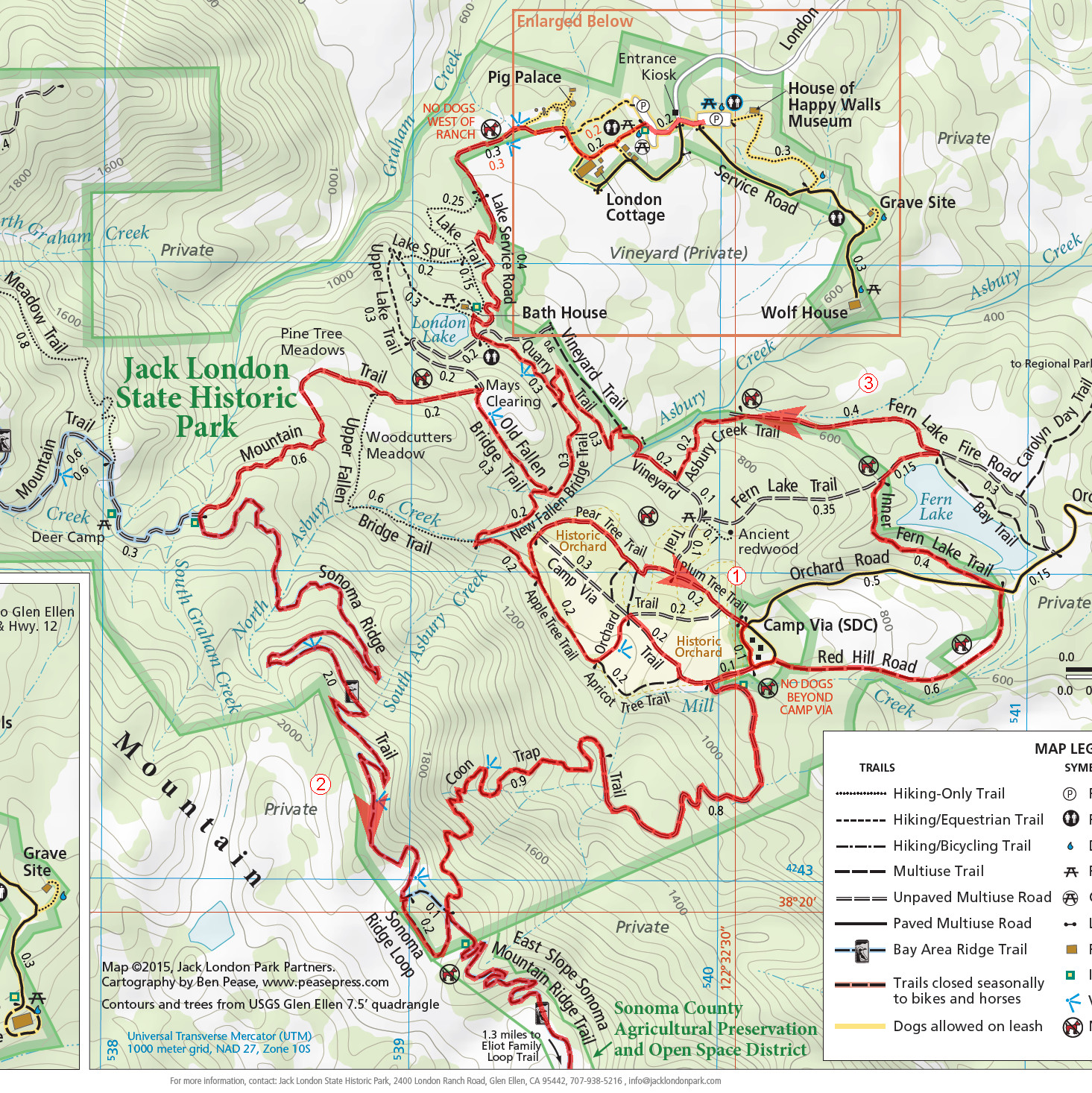
GPS Track Suggested Parking Park Map: Highlighted Original (PDF) Topographic Map Park Website Photos |
Jack London Park 67% SINGLETRACK30% FIRE ROAD3% ROAD 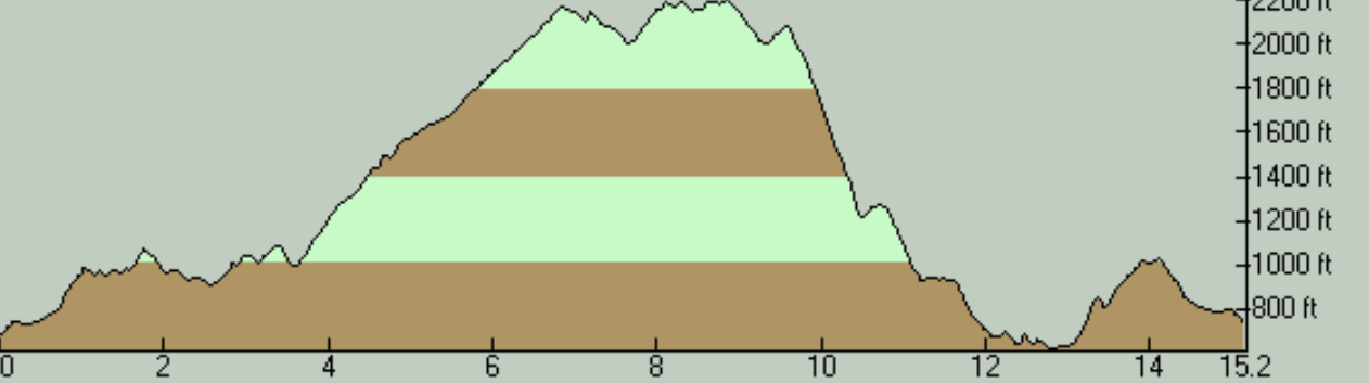
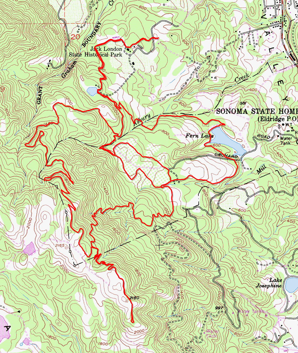
As a candidate for a bike ride, Jack London State Historic Park is a ride location that I'd been consciously ignoring for a long time. The reason was my long-standing impression that this park doesn't have good biking trails and that it offers little more than steep fire road climbs. When I did finally decide to try out this ride, part of me was still expecting the experience to be more like trying out a bike ride in a park that's popular mainly with hikers. This ride showed me how wrong I was. While the trail network of Jack London Park does have more than its fair share of steep climbs (more on that below), it also features way more bike-legal narrow trails than I was expecting. This is especially so in comparison to my mistaken expectations, which stemmed from impressions I had gained when I hiked here in an earlier life, which was well over a decade earlier than this ride. When I hiked here in 2004, the total trail mileage in the park was very limited and it seemed that very little of it was of a type that would be interesting to a mountain biker. When I look at a trail map of the park from 2008, I see that at least one trail segment I used on this ride wasn't yet legal for bikes (Old Fallen Bridge Trail). In addition, one fun leg of the ride (East Slope Sonoma Mountain Ridge Trail) is a 2015 introduction. So, my prejudice may not have been wholly unfounded, but I certainly could have devoted more attention to this park earlier than I did. The trails at Jack London Park are not technical in the sense in which a seasoned mountain biker would understand that term. One possible exception to this is the descent on Coon Trap Trail, which is steep enough and sometimes rough enough to pose problems to inexperienced riders. Advanced riders, meanwhile, may not think much of this descent's difficulty, other than the fact that it's fast. One exception to this may be one particular spot that's so steep that even bolder riders may take a pause. The terrain of the park actually has some parts that are quite rocky, which reminded me of Annadel, especially due to its proximity. But this rockiness isn't spread throughout all of the trail mileage. It's only clustered in a few places. One of the more commonly encountered things on the ride, and possibly the closest thing to a "technical trail feature" on this route, is a form of "pavement" of roughly hewn rocks used in spots where the trail appears to suffer from drainage problems. Greener riders may feel their skills tested by some of these, though many of these may not even be noticed by experienced bikers. Few of the trails on this ride maintain a judicious grade with any level of consistency, though the ones that actually do add up to quite a bit of mileage. A common theme here seems to be short and punchy climbs that can come at you at any moment, and sometimes for little apparent reason. This is true mostly of the fire roads (with Mountain Trail being one of the worst offenders), though I've noticed it on singletrack trails as well. The latter may sound like they could be meant as "playful trail undulations" added for fun, but I didn't feel the execution was well enough to qualify for that justification, and some examples were on older trails that appear to have transformed to singletrack only over time. The park features two large parking lots. With only a single ride here under my belt, I don't have any idea as to how crowded these can get. If they can, I didn't see any good backup parking options nearby. In such cases, it should be feasible to park near the Glen Ellen town center and bike your way up London Ranch Road from there, even if this adds nearly 500 feet to the ride's total elevation gain. Entering the park by car for day use is subject to a $10 fee as of 2020, and you pay at a gatehouse featuring an attendant. I haven't checked whether entering the park by bike is subject to any charge. The ride begins by taking you through some of the historic, stone buildings of Jack London Ranch. As you head into the park, you initially skirt around the Jack London Vineyard. Some of the steeper climbs of the ride greet you as soon as you turn away from this vineyard and start climbing the uphill portion of Lake Service Road. However, this particular ride route diverts you off that fire-road climb and onto some singletrack after only a quarter mile of suffering. On this diversion, Quarry Trail followed by New Fallen Bridge Trail serve as a nice, shaded singletrack stretch that continues level on average. Here, I've also included a sub-loop to explore the "historic orchard" area of the ranch. There's actually not a lot of this orchard to be seen in practice, with the exception of the southwestern corner of the loop. So, if that doesn't sound that enticing to you, you wouldn't miss out too much if you leave out the orchard, although the fact that a brief portion of the loop is singletrack will boost your overall singletrack mileage a little bit and the portion of New Fallen Bridge Trail that you use for connecting to the loop is also a quite fun singletrack. Whether you do the orchard sub-loop or not, I do find it worthwhile to take the roundabout singletrack route over Quarry, New Fallen Bridge, and Old Fallen Bridge Trails to bypass a short, early stretch of Mountain Trail. Old Fallen Bridge Trail does hand you off to Mountain Trail eventually anyway, on the edge of a small, sunny meadow marked as "Mays Clearing" on the park's map. Although the nearly half-mile segment of the ride on Old Fallen Bridge Trail is also a significant climb, the part that begins when you return to Mountain Trail feels like one of the tougher climbing stretches of the ride. You only cover about one more mile on Mountain Trail before you turn back onto singletrack and the average slope of this mile (7.5%) is even less than that of Old Fallen Bridge Trail (10%), but it's not even and it seems to have a disproportionate number of spots where the grade briefly appears to approach 20%. Your turn from Mountain Trail onto Sonoma Ridge Trail feels welcome not only because it's a return to singletrack but also because it brings an initial half-mile (or so) stretch where the grade slackens to just under 4.5% on average. Sonoma Ridge Trail is clearly one of the trails built to be a park trail (rather than being a converted ranch road, etc.) as you can tell not only by the fact that it's narrow enough to qualify as good singletrack, but also by the judicious grade it maintains as it gains elevation. Even the steeper final portion of the trail (the last 1.2 miles, roughly) has a grade that averages a hair under 7%. It's a pleasant hillside singletrack that climbs under adequate and pretty tree cover, following multiple switchbacks on the way. The trail ends with a tiny (roughly quarter-mile) loop right at the park's boundary near the spine of Sonoma Ridge. When passing through this little loop, I followed its higher half hoping it might be a touch more scenic, but that still didn't present any interesting views, and neither did the rest of the climb there, due to the persistent tree cover. You only get a peek from one or two specific spots on the way up and that's it. What I did on the other side of the little Sonoma Ridge Loop at the park boundary is an out-and-back on the uneconomically named "East Slope Sonoma Mountain Ridge Trail". Let me call it "East Slope Trail" in the rest of this text. After dipping a little to cross the head of a gully that starts near the ridgetop, East Slope trail climbs back up the other side of it before beginning to alternate between ups and downs mostly around the same average elevation. This trail almost immediately leaves the Jack London Park boundary actually, and most of its 2.2 miles extend into other open space district lands that adjoin the park. It will cost you an extra 350 feet in cumulative elevation gain to traverse this spur of the ride route, but it's one of the more worthwhile stretches of the ride because a lot of this trail traverses grassy terrain, so the views from the top of Sonoma Ridge are unimpeded and easily the best on this ride. Perhaps a little interestingly, East Slope Trail too ends by connecting to a tiny loop. Despite having it's own name (Eliot Family Loop Trail), this one is no bigger than many traffic roundabouts in some major cities, at a little over 100 yards in length. Though it's a nice, shady, and narrow trail, its tiny length will leave you with little more than the knowledge of having done it. After East Slope Trail, what comes next is the ride's "big descent", which is on Coon Trap Trail. The descent on this steep, occasionally rocky, and sometimes widened singletrack lasts only a bit over a mile and a half actually, and that includes a quarter-mile break on the way down that alternates between flat and a short uphill stretch that takes a bit of real pedaling to climb. Most significantly, though, more than a half-mile stretch of this descent averages a crazy -20.5% grade end to end. This portion has spots where even experienced riders would do well to be careful about the transitions of the rutty trail surface and occasional slippery spots, and beginner riders should really beware. After the break in this descent that I mentioned, the slope turns a lot more sane, but would still qualify as "steep". About a quarter mile of this second part of the descent still manages to average -15.5% grade end to end. Right after crossing a minor stream shortly after the end of that steep climb, Coon Trap Trail spits you out at the southeastern end of that same orchard sub-loop I described earlier. From this point on, I followed a roundabout route to return to the beginning in an effort to string together a couple more potential singletrack stretches that I saw on the park map (Red Hill Road, Inner Fern Lake Trail, and Asbury Creek Trail). I'd say that my route choice here turned out to be questionable at best. Red Hill Road turned out to be more fire road than singletrack, Inner Fern Lake Trail had a ridiculously overgrown portion at the time of my ride, and Asbury Creek Trail was most memorable for an unreasonably steep climb. I won't describe this leg of the ride in any more detail than this for the simple reason that I won't be repeating this routing when I do this ride again. I'd much rather try following Vineyard Trail away from the historic orchard area to connect back to the beginning. Your return to the area of the ranch buildings may be your best opportunity to spend some time taking in some stories and relics of Jack London's life. Here, you can see the cottage where Jack London lived, the ruins of the house (Wolf House) that was built as a replacement for that cottage, Jack London's grave, a museum, a visitor center, a display of old ranch equipment, and so on. When planning your ride, you should be aware that Coon Trap Trail (which is part of this ride route) is marked on the park's map as being subject to seasonal closure to bikes and horses. I'm not aware of the dates of this closure, but I would expect it to coincide with the rainy winter season. © Ergin Guney
Comments: blog comments powered by Disqus |