 |
| What's New | Links | FAQ | Contact |

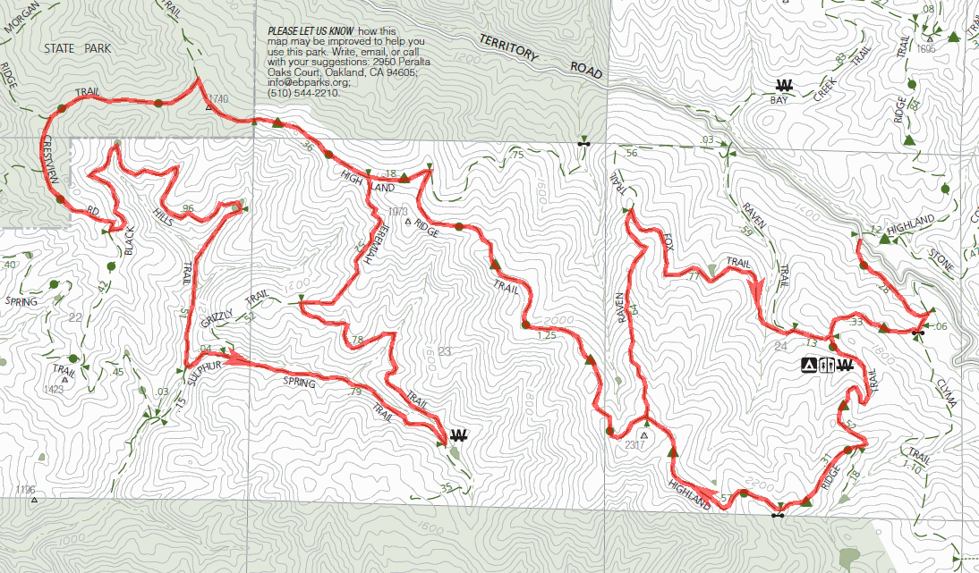
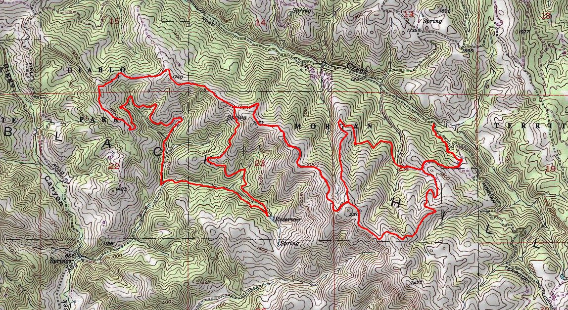
GPS Track Suggested Parking Park Map: Highlighted Original (PDF) Topographic Map Park Website Photos |
Morgan Territory (western trails) 100% FIRE ROAD 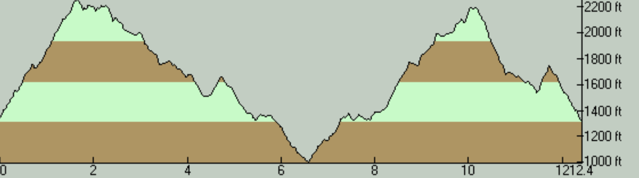
THE PARKThis is an all-fire-road ride deep in the East Bay hills with very steep climbs. Morgan Territory Regional Preserve is one of the open space areas that share a border with Mount Diablo State Park, in the hills southeast of Mount Diablo, in an area called the Black Hills. This is a spot that is as remote as it's going to get in the East Bay hills. The trailhead is accessed by traveling several miles on a one-lane road. It's ideal for those who like to commune with nature in isolation. It's pretty much a "wilderness" setting and the nature is beautiful with painting-like oak woodlands on terrain that's always interesting with never a flat spot. The views, as well, are top-notch. Much of the ride takes place against an up-close view of Mount Diablo in the background, and you can catch sights reaching Pleasanton on one side, and the Delta and the Central Valley on the other. On a clear day, the tall buildings in downtown Sacramento can be spotted. THE RIDEAs a mountain bike ride, this is likely to appeal only to those who would take pleasure from the beautiful nature and the views, or are masochistic or superhuman enough to enjoy the trails. If you don't like climbing, you might want to look for other ride options. This ride is a typical East Bay ride, to the second power: All bike-legal trails are fire roads and all the climbs and descents are very steep. The slopes routinely exceed 20% grade. Keen observers of this site might notice that I've rated the aerobic difficulty of the ride to the peak of Mount Diablo as an 8 and this ride shows the same rating, despite the fact that the Mount Diablo ride has 600 more feet of elevation gain. That's not a mistake. I find this ride just as challenging, possibly because the Mount Diablo ride has most of its steepest climbs confined to about a three-mile stretch of the ride; you get in a climbing mindset, get through it, and it's over. Here, however, all the intermittent climbs over the entire 12 miles of the ride seem to be of the same difficulty as the worst climbs at Mount Diablo. They're not as continuous, but the overall effect is exhausting. Speaking of trails, the trails along this route are purely fire roads. The trails pose virtually no technical challenges with the possible exception of soggy spots and ruts in the wet season, but I still had a couple of issues with them. First of all, some of the drier parts of the trails were covered by pretty soft soil on one particular ride, adding to the difficulty of the climbs, and of even some of the flats. The second issue is that, when the trail is partially moistened without being thoroughly soaked and there's still a dry layer just under the surface (as were the conditions during the beginning of my ride there due to condensation from fog), the soil is sticky enough to accumulate on your tires (and many other places on your bike) in great quantities. The strange end result is that your bike gets covered in mud without riding in mud. Finding the trailhead for this ride might be a little tricky. It consists of a small roadside parking area large enough for 8 or 10 cars and is miles from the nearest intersection. It might be a good idea to carefully examine the ride photos and the Google Street View of this spot by following the Suggested Parking link on your left. If you prefer to find the place using your vehicle's trip counter, reset your mileage right when you turn onto Morgan Territory Road (whether from the south, off Manning Road; or from the north, off Marsh Creek Road) and you'll be at the trailhead at about the 7.1-mile mark if coming from the north or the 7.6-mile mark when coming from the south. The easiest way of verifying that you're at the right spot is to look for the two green metal trail gates facing each other on opposite sides of the road, one of which has a sign that reads "Highland Ridge Trail". (See the photos linked on your left.) It's worth noting that what's typically listed as the "Morgan Territory ride" by most other sources is a route on the other (eastern) half of the park. This ride is in the western half of the park instead. This side of the park is arguably a bit more suitable for putting together longer rides (at least within the park boundaries). Morgan Territory is quite rich in opportunities for extending your ride. One obvious option would be to continue onto the eastern half of the park, though you should hold no hope of the climbs getting any easier in that area. Another option would take you to Round Valley Regional Preserve, though it seems you have to ride through Los Vaqueros Watershed to get there and the Morgan Territory map states that this requires a permit and is subject to a fee (though I see no mentiokn of this at the Los Vaqueros website). There are much richer opportunities if you continue into Mount Diablo State Park from the western end of this ride route. That option opens up route possibilities that you probably couldn't exhaust in a week. This might make the western half of Morgan Territory more desirable to those looking for longer rides, because I'm not sure there is a connection available from the eastern half to the Mount Diablo trails. One final note I'd like to add is that, if you decide to do this ride in search of pretty nature, you should make sure that you don't turn back before you complete the loop on the western end of this route. While the ridgetop portions around the middle of the route have the expansive views into the surrounding areas, the loop on the west has arguably the prettiest nature of the entire ride, where it descends next to creek beds shaded by large oak trees. You might even be able to catch some fall foliage around there if you can time your ride well. © Ergin Guney
Comments: blog comments powered by Disqus |