 |
| What's New | Links | FAQ | Contact |

GPS Track Suggested Parking Topographic Map Photos |
Three Bears Loop 100% ROAD 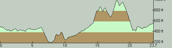
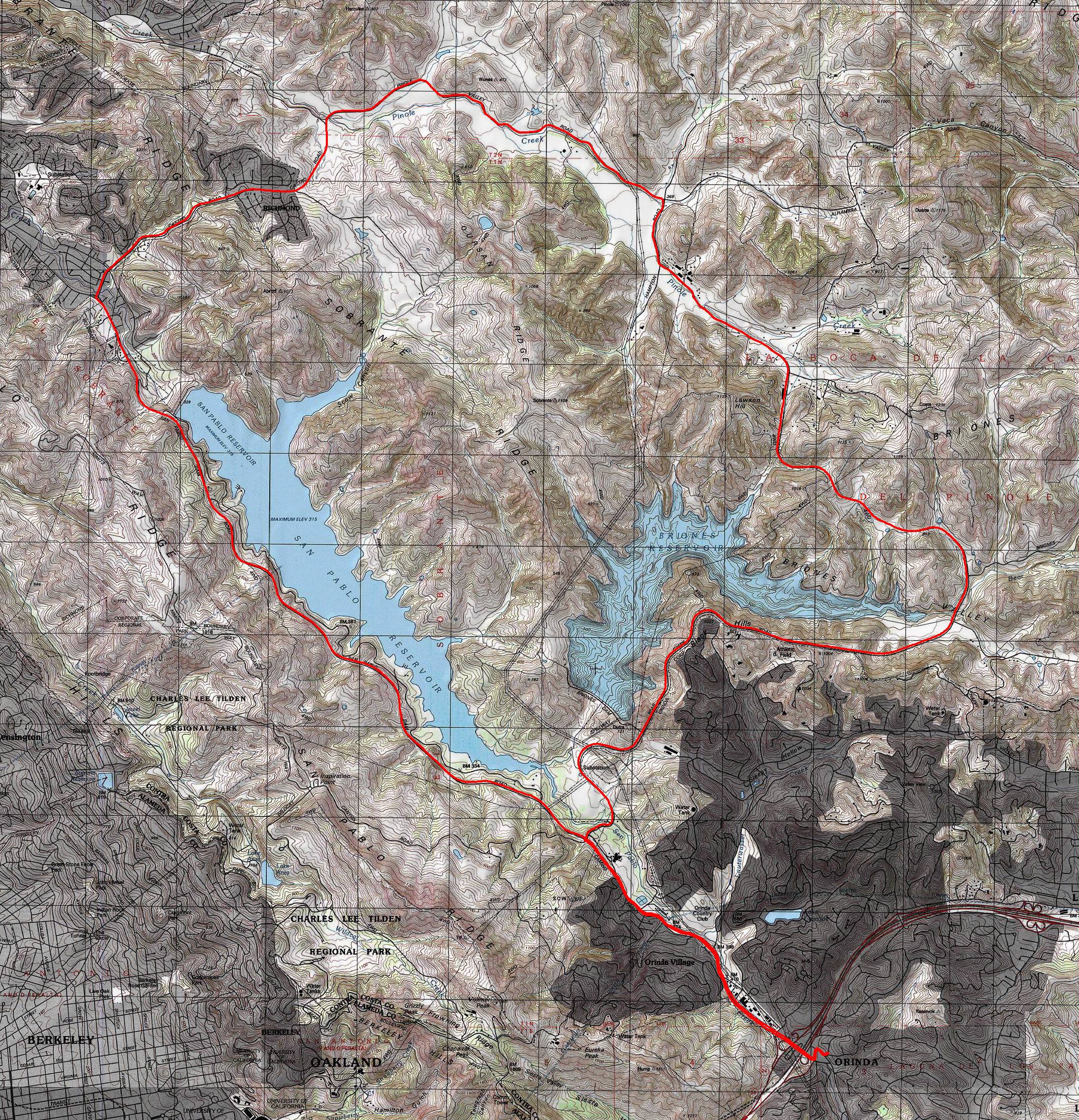
This is one of the most well-known road rides in the East Bay. It's a staple in guide books. You probably can't find any road ride guide book in print with coverage of the East Bay that does not list this loop. The fact that the route has a commonly recognized nickname also attests its popularity. The reason is not a big mystery. The route is within easy pedaling range from several small East Bay settlements like Orinda, Lafayette, and Moraga, as well as being accessible from Berkeley via Wildcat Canyon Road. For those who will be driving to get here, it's within minutes of driving time from an even longer list of East Bay cities. That's very good for a ride that is mellow enough to be suitable for a fairly wide range of skill levels, not to mention being a pretty idyllic one—more than half the loop takes place in the cute scenery of uninhabited backcountry. For anyone who isn't already familiar with this route, the nickname of the ride cries out for an explanation. The "three bears" are three noteworthy climbs on Bear Creek Road, which are almost the ride's only significant climbs. The first of these is "Mama Bear", which arrives a little bit past the 14-mile mark of the route shown on this page. This half-mile climb with an average slope just under 8% grade is certainly enough to make you take notice, but it's not enough to test the will of any riders other than those who are the most out of shape. The "Papa Bear" climb deserves a bit more respect, but only because it includes a quarter-mile introductory stretch whose average grade doesn't even reach 5%. Not counting that addition, Papa Bear would come out to be almost identical to Mama Bear: a touch over half a mile in length and just under 8% in overall average grade. That only leaves "Baby Bear", which is a bit like the last hurrah of Bear Creek Road. In the last 900 feet or so of Bear Creek Road before it ends at Camino Pablo, the road decides to do one last climb where it gains 90 feet in elevation. While that's not a big climb in quantity, it is in terms of slope, because the ride's single steepest spot arrives in this stretch. At its steepest point, Baby Bear attains at least a 16% grade and possibly as high as 18% for one brief moment. But those are over in seconds. Since this is a loop that gets its nickname from specific climbs on the route, it automatically follows that there is an implied direction for its traversal. You need to do the loop clockwise in order to experience the "bears" as climbs. However, while that may be the direction of traversal from which the ride gets its name, it's also very common to do it in the opposite direction. It's worth keeping in mind, though, that doing the loop counter-clockwise will mean that you'll be riding the route's single longest slope as a climb. This 1.5-mile portion that would start shortly after you turn onto Bear Creek Road averages only about a 6.5% grade end to end, but its slope fluctuates a little. You would encounter at least four stretches where the grade will reach into the 10-to-12 percent range. The descent that starts near the San Pablo Dam on this particular version of the ride also turns into a climb, naturally, when you do the loop counter-clockwise. That one would be almost exactly a one-mile-long climb for you with an end-to-end average grade of exactly 5%. But you will temporarily see 7 or 8 percent grade at a few spots on that climb too. What all that slope analysis means to me is that this is a moderate ride in overall difficulty. In other words, the modest total elevation gain figure you see listed for the ride is a correct indication of what can be expected. There are no unpleasant surprises along the way either, other than the eye-opening slope that "Baby Bear" inflicts upon you for one brief moment. Green riders who are okay with some climbing but are not exactly ready to grind uphill all day long should, therefore, not have any problem on this ride. Meanwhile, for seasoned riders in tip-top shape, this ride can easily be pulled off in less than two hours as a quickie after-work spin, or a morning workout between your breakfast and your shower even on a work day. I picked the town center of Orinda as the starting point for a ride of the Three Bears Loop because it happens to be the closest town that can provide a great selection of food and coffee right where you finish your ride. For parking, I don't have any specific suggestion I can share. I normally use street parking in Orinda. You need to know, however, that street parking on most blocks near the town's center is subject to a time limit, which is two hours in some places but can be as little as one hour on the main drag. But those limits are not in effect on weekends and holidays on most blocks. It's also worth pointing out that the Theater Square garage right in the heart of downtown is free for unlimited parking on weekends. (On weekdays, it only allows three hours of free parking with validation.) The very beginning of the route (as well as the very end when you traverse that same stretch again) involves the hairiest interaction with car traffic on the ride. The part of Camino Pablo heading out of Orinda is its busiest portion, with the worst of it at the Route 24 underpass where you need to thread through on-ramp and off-ramp traffic, though a prominent bike lane painted solid green in that short stretch should make the drivers around you a bit more conscious of your existence. If biking through a stretch like that may bother you too much, it's actually not such a bad idea to begin the ride near the intersection of Camino Pablo and Camino Sobrante instead. That should allow you to avoid all of the highway intersection traffic, and there are coffee shops and a good selection of eateries there and on the nearby Orinda Way as well. While the traffic density on Camino Pablo tapers off a little as you head northeast on this road (and then onto its continuation, San Pablo Dam Road), this overall stretch still has moderately heavy traffic to the end of its extent that's included on this ride. The ride's trickiest stretch in terms of the availability of safe space for a bicycle on the road also arrives on Camino Pablo. While most of this road has reasonable paved shoulder space, through one (roughly) quarter-mile stretch between Miner Road and Manzanita Drive, this road squeezes into a narrower width and brings you uncomfortably close to the car traffic. On the side of the road you'll use here in the first half of the ride, the badly narrow stretch where the bike lane disappears is very short. The bike lane here actually diverts into a paved path next to the road intended for bypassing this stretch. This paved path itself splits into two almost immediately. Stay to the left here (which is what you'll see the route on this page doing, if you look closely); the branch on the right appears to be intended only as a foot path and it continues on for a while longer more like a sidewalk. The left-hand option merges back onto the road only after about 400 feet and becomes a roadside bike lane once again. As you are passing through the same stretch again near the end of the ride, the side of the road you're on will also allow a bypass option, though it might not look obvious the first time you see it. You'll see the shoulder of the road diverting away from the main road there and taking you via a tiny paved connector to what looks like a frontage road that doesn't actually connect to Camino Pablo for car traffic. Bikes should take that side road, which is actually suggested explicitly by at least one sign that was there the last time I saw the place. This little side road (which is also labeled as "Camino Pablo" by Google Maps, oddly enough) later allows you to merge back onto Camino Pablo via another little paved path; though, once again, motor vehicles couldn't use it for that. Things get much quieter when you turn onto Castro Ranch Road. During your short stint of roughly two miles on this road, the scenery alternates a couple of times between rural and almost suburban. Shortly before you reach Alhambra Valley Road, Castro Ranch Road emerges onto open country for good. This beautiful scenery stays with you as you continue on Alhambra Valley Road. This is the most minor and the most lightly used road on this route. You'll be surrounded by beautiful backcountry scenery here. The road still has some traffic, but it's very light. When you turn from Alhambra Valley Road onto Bear Creek Road, things don't change much. If anything, Bear Creek Road initially looks and feels even more minor than Alhambra Valley Road. That doesn't last very long, however. Around the point where you reach the beginning of the "Mama Bear" climb, Bear Creek Road suddenly becomes an impecabbly paved, spacious two-lane with generous paved shoulder space on both sides. It then stays that way right up to where it reaches the "Baby Bear" climb. On your way there, you make it through the bigger two out of the three climbs that give this loop its name, along with a descent down the route's longest unbroken slope, which begins right after the end of the "Papa Bear" climb as I already mentioned. The route has fairly limited tree cover. San Pablo Dam Road and Castro Ranch Road have a couple of shady patches. The longest shady stretch comes in the later parts of Alhambra Valley Road. Trees don't exactly hang over the road here either, but a tall row of eucalyptus trees are on the correct side of the road to leave it in shade during the afternoon. For a ride with such patchy tree cover, the views are not as unbroken as you might expect. Even though there aren't trees over the road for most of the ride, a lot of the distance on the route is covered in the presence of trees on both sides of the road. As a result, the scenic parts of the ride are limited in length. San Pablo Dam Road sees nice views of the San Pablo Reservoir from a few stretches, though probably not as many as you might think. The road is flanked by nice grassy expanses during the last part of Castro Ranch Road and for most of Alhambra Valley Road. Bear Creek Road also provides some nice views of grassy slopes and a meadow or two between the Mama Bear and Papa Bear climbs. Despite this road's proximity to it, the Briones Reservoir is a body of water that you get to see from very few vantage points on this ride. © Ergin Guney
Comments: blog comments powered by Disqus |